IMAGES TAKEN NEAR TO
Raw Brae Road, CARRICKFERGUS, BT38 9SZ
Introduction
This page details the photographs taken nearby to Raw Brae Road, BT38 9SZ by members of the Geograph project.
The Geograph project started in 2005 with the aim of publishing, organising and preserving representative images for every square kilometre of Great Britain, Ireland and the Isle of Man.

There are currently over 7.5m images from over14,400 individuals and you can help contribute to the project by visiting https://www.geograph.org.uk
Image Map
Images are licensed for reuse under creativecommons.org/licenses/by-sa/2.0
Notes
- Clicking on the map will re-center to the selected point.
- The higher the marker number, the further away the image location is from the centre of the postcode.
Image Listing (5 Images Found)
Images are licensed for reuse under creativecommons.org/licenses/by-sa/2.0
Image
Details
Distance
1
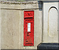
Victorian wall box (BT38 286) near Whitehead (1)
A Victorian wall box on the Rawbrae Road, close to Quay Lane. I noted the number (BT38 286) at the time of the photograph and verified it by zooming in on the photograph. The official number is given, elsewhere, as BT38 337. Image shows the box in its geographical setting.
Image: © Albert Bridge
Taken: 22 Apr 2014
0.05 miles
2
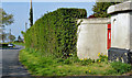
Victorian wall box (BT38 286) near Whitehead (2)
See Image The box (BT38 286) in its setting along the Rawbrae Road, close to Quay Lane.
Image: © Albert Bridge
Taken: 22 Apr 2014
0.05 miles
3
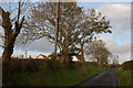
Quay Lane near Whitehead (2)
See Image This is the part of the Quay Lane on the other side of the Carrickfergus-Larne road. It runs to the Rawbrae Road and thence to Whitehead. This is the view towards the Rawbrae Road.
Image: © Albert Bridge
Taken: 14 Nov 2006
0.21 miles
4
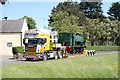
Unusual Load
RPSI 3 about to pass Quay Lane on its journey to the Downpatrick & Co.Down Railway Society at Downpatrick.
Image: © Wilson Adams
Taken: 11 Jun 2006
0.21 miles
5
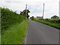
Raw Brae Road, Carnbrock
Heading north-east towards Wellhead
Image: © Kenneth Allen
Taken: 1 Jun 2010
0.24 miles