IMAGES TAKEN NEAR TO
Quay Lane, CARRICKFERGUS, BT38 9SS
Introduction
This page details the photographs taken nearby to Quay Lane, BT38 9SS by members of the Geograph project.
The Geograph project started in 2005 with the aim of publishing, organising and preserving representative images for every square kilometre of Great Britain, Ireland and the Isle of Man.

There are currently over 7.5m images from over14,400 individuals and you can help contribute to the project by visiting https://www.geograph.org.uk
Image Map
Images are licensed for reuse under creativecommons.org/licenses/by-sa/2.0
Notes
- Clicking on the map will re-center to the selected point.
- The higher the marker number, the further away the image location is from the centre of the postcode.
Image Listing (15 Images Found)
Images are licensed for reuse under creativecommons.org/licenses/by-sa/2.0
Image
Details
Distance
1
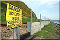
Railway sign near Whitehead (1)
There are some houses close to the railway between the cliffs and the shore. There seems to be a right of way from them to the lineside path Image This sign is at the gap in the safety fence – a sort of GOMR. It is inaccurate since the down line is no longer in use. The view is towards Whitehead with Belfast Lough on the right.
Image: © Albert Bridge
Taken: 3 May 2008
0.13 miles
2
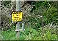
Railway sign near Whitehead (2)
See Image There is a similar sign inside the fence - beside the disused down line.
Image: © Albert Bridge
Taken: 3 May 2008
0.13 miles
3
Railway path near Whitehead (2)
See Image The path narrows to the SW of the previous photo. It disappears completely just behind me.
Image: © Albert Bridge
Taken: 3 May 2008
0.13 miles
4
Quay Lane near Whitehead (1)
The Quay Lane originally served a few houses and the old White Harbour. It was re-built as the access to Cloghan Jetty Image and has ceased to be a lane. This is the view towards the Carrickfergus-Larne road.
Image: © Albert Bridge
Taken: 5 Sep 2006
0.15 miles
5
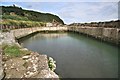
White Harbour, Whitehead
White Harbour, so-called because it is constructed mainly of white limestone blocks, was constructed around 1850. In recent decades it lay derelict, but was purchased in 1988 by a local businessman, who has encouraged local pleasure boat owners to moor their craft in the sheltered harbour.
However, a silted entrance and dangerous gaps in the quay edge have forced substantial improvements. Currently (August 2014) all craft have been temporarily removed, the entrance is being dredged and workmen are repairing the limestone blocks that form the quay wall and steps.
Image: © Bob Jones
Taken: 20 Aug 2014
0.15 miles
6
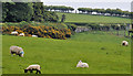
Fields near Whitehead
Sheep grazing in a field, on the higher ground overlooking Belfast Lough, on the Whitehead side of Quay Lane Image Hawthorn blossom and whins mark the Belfast Road (shown as Princess Park (!) on the Google map).
Image: © Albert Bridge
Taken: 7 May 2011
0.18 miles
7
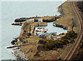
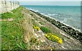
The White harbour, Whitehead
A small harbour, facing Belfast Lough, to the south west of Whitehead built for the export of locally-quarried limestone Image The Belfast – Larne Harbour railway is on the right.
Image: © Albert Bridge
Taken: 17 Mar 2010
0.18 miles
8
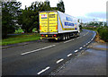
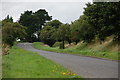
The A2 near Whitehead
The A2 road between Whitehead and Carrickfergus.
Image: © Rossographer
Taken: 18 Jun 2011
0.19 miles
9
Railway near Whitehead and Cloghan
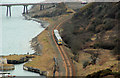
The railway follows the shore of Belfast Lough for most of the journey between Downshire Image and Whitehead Image stations. In this case the 11.19 Belfast Gt Victoria Street – Larne Harbour (Saturday timetable for the Bank Holiday) is approaching the old White Harbour Image (bottom left) after passing the Kilroot power station oil tanks landward of Cloghan jetty Image (top). The line, now single, was once double track.
Image: © Albert Bridge
Taken: 17 Mar 2010
0.19 miles
10
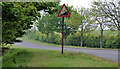
Steep hill sign near Whitehead
Road signs showing the gradient are now all in metric Image This imperial survival (1in6 – 16%) is at the main road end of Quay Lane Image). Quay Lane leads down to Cloghan jetty and the White Harbour (sea level) – both of which can be seen in Image
Image: © Albert Bridge
Taken: 7 May 2011
0.19 miles