IMAGES TAKEN NEAR TO
York Avenue, CARRICKFERGUS, BT38 9QT
Introduction
This page details the photographs taken nearby to York Avenue, BT38 9QT by members of the Geograph project.
The Geograph project started in 2005 with the aim of publishing, organising and preserving representative images for every square kilometre of Great Britain, Ireland and the Isle of Man.

There are currently over 7.5m images from over14,400 individuals and you can help contribute to the project by visiting https://www.geograph.org.uk
Image Map
Images are licensed for reuse under creativecommons.org/licenses/by-sa/2.0
Notes
- Clicking on the map will re-center to the selected point.
- The higher the marker number, the further away the image location is from the centre of the postcode.
Image Listing (152 Images Found)
Images are licensed for reuse under creativecommons.org/licenses/by-sa/2.0
Image
Details
Distance
1
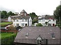
Houses above Beach Road, Whitehead
The image was taken from the Larne Line.
Image: © Eric Jones
Taken: 30 Jun 2017
0.01 miles
2
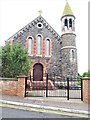
Our Lady of Lourdes Catholic Church, Whitehead
This church is served from Carrickfergus. A Catholic Primary School is located at the rear of the chapel.
Image: © Eric Jones
Taken: 30 Jun 2017
0.03 miles
3

Picnic area
Grassland picnic area off Beach Road
Image: © Mat Tuck
Taken: 5 Jun 2014
0.05 miles
4
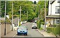
York Avenue, Whitehead
A residential cul-de-sac, on the south western side of the Cable Road Image
Image: © Albert Bridge
Taken: 26 May 2009
0.05 miles
5
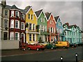
Marine Parade.Whitehead
Colourful houses on the seafront.
Image: © Paul McIlroy
Taken: 22 Oct 2005
0.06 miles
6
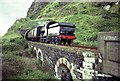
Whitehead Tunnel
GSR 461, emerges from Whitehead Tunnel heading for Larne Harbour
Image: © Wilson Adams
Taken: Unknown
0.06 miles
7
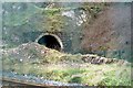
Whitehead Tunnel
Whitehead Tunnel has been disused since the mid 1990's due to its unsafe condition. The present day trains travel round the outside of Whitehead Cliffs using the Up line to Belfast.
The image was made through a railway security fence, erected to keep trespassers off the railway line.
Image: © Wilson Adams
Taken: 3 Jan 2007
0.06 miles
8
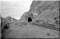
Whitehead Tunnel
Whitehead Tunnel at the foot of White Head Cliff, looking towards Belfast.
The railway Line on the left, leads to Belfast, while that on the right leads to Whitehead and Larne Harbour.
Image: © Wilson Adams
Taken: Unknown
0.06 miles
9
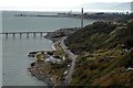
View from the Bla' Hole
View made from the Bla' Hole, looking towards Belfast showing, The White Harbour, part of Cloughan Point Oil Jetty, The Salt Mines Jetty and Killroot Power Station Jetty. In the background Belfast Harbour can also be seen.
Image: © Wilson Adams
Taken: 22 Oct 2005
0.06 miles
10
Railway Tracks
A view from the Bla' Hole, Image of a train travelling towards Belfast in grid Image The train is on the Up line travelling towards Belfast, this section of line is now single track between Whitehead and the Salt Mines at Killroot. The railway line to the right of the train, is the now disused Down line from Belfast to Whitehead and Larne Harbour. This line passes through Whitehead Tunnel, before reaching Whitehead. The area between the two tracks, was where the original Whitehead Station once stood.
A word of advice for anyone wanting to recreate an image similar to this one is "DON'T!, as I was standing two feet from the cliff edge, and it's an approx sheer drop of 800 foot to the railway lines below.
Image: © Wilson Adams
Taken: 24 Mar 2004
0.06 miles