IMAGES TAKEN NEAR TO
Marine Parade, CARRICKFERGUS, BT38 9QN
Introduction
This page details the photographs taken nearby to Marine Parade, BT38 9QN by members of the Geograph project.
The Geograph project started in 2005 with the aim of publishing, organising and preserving representative images for every square kilometre of Great Britain, Ireland and the Isle of Man.

There are currently over 7.5m images from over14,400 individuals and you can help contribute to the project by visiting https://www.geograph.org.uk
Image Map
Images are licensed for reuse under creativecommons.org/licenses/by-sa/2.0
Notes
- Clicking on the map will re-center to the selected point.
- The higher the marker number, the further away the image location is from the centre of the postcode.
Image Listing (206 Images Found)
Images are licensed for reuse under creativecommons.org/licenses/by-sa/2.0
Image
Details
Distance
1
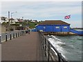
Rangers Football Club, Whirehead
Pictured along Marine Parade
Image: © Kenneth Allen
Taken: 22 May 2012
0.02 miles
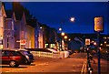
2
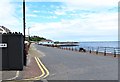
View North along Whitehead's Marine Parade
The image was taken from the junction with Marine Avenue.
Image: © Eric Jones
Taken: 30 Jun 2017
0.03 miles
3
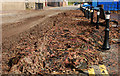
Seaweed, Whitehead
This is a small part of an overnight accumulation of seaweed, washed ashore during high winds. Work was underway (behind me) to remove it. It was very deep. The men from the Roads Service needed the help of a “Bobcat”. See also Image
Image: © Albert Bridge
Taken: 8 Sep 2010
0.03 miles
4
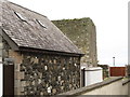
Castle Chichester, Whitehead
This is an early 17thC tower house built by Sir Moyses Hill, a landless adventurer, whose family - the Downshires - were to become one of Ulster's largest landowners. The castle and its surrounds are in private ownership and there is no public access from the public highway (Chester Avenue) from where this image was taken.
Image: © Eric Jones
Taken: 30 Jun 2017
0.03 miles
5
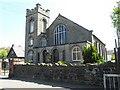
Congregational Church, Whitehead
It is located along Chester Avenue
Image: © Kenneth Allen
Taken: 28 Apr 2011
0.03 miles
6
Marine Parade, Whitehead (3)
Image: © Albert Bridge
Taken: 7 Nov 2008
0.04 miles
7
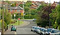
Chester Avenue, Whitehead
Chester Avenue runs from the station Image towards the Slaughterford Bridge Image and the Belfast – Larne road. The name comes from Castle Chester – a tower house built in 1604 – out of picture to the right.
Image: © Albert Bridge
Taken: 26 May 2009
0.04 miles
8
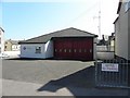
Fire Station, Whitehead
It is located along Chester Avenue
Image: © Kenneth Allen
Taken: 28 Apr 2011
0.04 miles
9
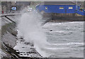
Rough sea, Whitehead (2)
Waves breaking at Marine Parade Image, on a not a particularly windy day, at two hours before low water, Carrickfergus. Not strong enough to wash the seaweed Image ashore.
Image: © Albert Bridge
Taken: 4 Feb 2012
0.04 miles
10
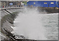
Rough sea, Whitehead (3)
Waves breaking at Marine Parade Image, on a not a particularly windy day, at two hours before low water, Carrickfergus. Not strong enough to wash the seaweed Image ashore.
Image: © Albert Bridge
Taken: 4 Feb 2012
0.04 miles