IMAGES TAKEN NEAR TO
Chester Avenue, CARRICKFERGUS, BT38 9QL
Introduction
This page details the photographs taken nearby to Chester Avenue, BT38 9QL by members of the Geograph project.
The Geograph project started in 2005 with the aim of publishing, organising and preserving representative images for every square kilometre of Great Britain, Ireland and the Isle of Man.

There are currently over 7.5m images from over14,400 individuals and you can help contribute to the project by visiting https://www.geograph.org.uk
Image Map
Images are licensed for reuse under creativecommons.org/licenses/by-sa/2.0
Notes
- Clicking on the map will re-center to the selected point.
- The higher the marker number, the further away the image location is from the centre of the postcode.
Image Listing (201 Images Found)
Images are licensed for reuse under creativecommons.org/licenses/by-sa/2.0
Image
Details
Distance
1

Playing fields, Whitehead
Municipal playing fields between the railway and the Castleview Road. Whitehead Golf Club’s wind turbines Image are at top left on Muldersleigh Hill Image
Image: © Albert Bridge
Taken: 19 Aug 2010
0.03 miles
2
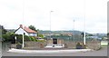
War Memorial in Chester Avenue, Whitehead
This is located at the entrance of the Recreation Grounds in Chester Avenue.
Image: © Eric Jones
Taken: 30 Jun 2017
0.03 miles
3
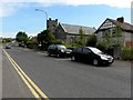
Chester Avenue, Whitehead
Heading NNE; to the right is the Congregational Church Image]
Image: © Kenneth Allen
Taken: 22 May 2012
0.04 miles
4

One-World Garden, Whitehead
“One-world Garden” in Chester Avenue. Said to symbolise the six continents of the world. Planted in 2008 to celebrate the “Britain in Bloom” theme of local roots.
Image: © Albert Bridge
Taken: 19 Aug 2010
0.04 miles
5

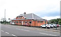
Whitehead excursion station
For the history of the line see the “shared description” below. Whitehead excursion station opened in 1907 to handle special trains for day trippers (mainly from Belfast) at a time when the town was seaside resort. In 1966 it became the base for the Railway Preservation Society of Ireland Image and Image The Larne line is on the left.
Image: © Albert Bridge
Taken: 19 Aug 2010
0.05 miles
6
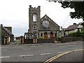
Whitehead Congregational Church
This is located in Chester Avenue.
Image: © Eric Jones
Taken: 30 Jun 2017
0.05 miles
7
Chester Avenue, Whitehead
Chester Avenue runs from the station Image towards the Slaughterford Bridge Image and the Belfast – Larne road. The name comes from Castle Chester – a tower house built in 1604 – out of picture to the right.
Image: © Albert Bridge
Taken: 26 May 2009
0.06 miles
8

Vacant house, Whitehead
A vacant house, in Chester Avenue, boarded up, confined behind razor wire and looking as if it’s awaiting the end of the recession before metamorphosing into apartments.
Image: © Albert Bridge
Taken: 19 Aug 2010
0.06 miles
9
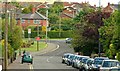
Sports pavilion in Islandmagee Road, Whitehead
The pavilion backs on to tennis courts bowling greens and other recreational facilities.
Image: © Eric Jones
Taken: 30 Jun 2017
0.06 miles
10
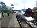
Generating steam, Whitehead
The No.85 Steam Locomotive has taken water on board and is heading backwards
Image: © Kenneth Allen
Taken: 28 Mar 2016
0.06 miles