IMAGES TAKEN NEAR TO
Donegall Drive, CARRICKFERGUS, BT38 9LT
Introduction
This page details the photographs taken nearby to Donegall Drive, BT38 9LT by members of the Geograph project.
The Geograph project started in 2005 with the aim of publishing, organising and preserving representative images for every square kilometre of Great Britain, Ireland and the Isle of Man.

There are currently over 7.5m images from over14,400 individuals and you can help contribute to the project by visiting https://www.geograph.org.uk
Image Map
Images are licensed for reuse under creativecommons.org/licenses/by-sa/2.0
Notes
- Clicking on the map will re-center to the selected point.
- The higher the marker number, the further away the image location is from the centre of the postcode.
Image Listing (47 Images Found)
Images are licensed for reuse under creativecommons.org/licenses/by-sa/2.0
Image
Details
Distance
1
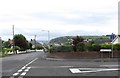
The Donegall Park junction on Donegall Avenue, Whitehead
The Whitehead headland forms the background.
Image: © Eric Jones
Taken: 30 Jun 2017
0.07 miles
2
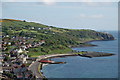
Whitehead from the Bla Hole
The town of Whitehead owes its existence to the Belfast and Northern Counties Railway which gave free season tickets to anyone building a villa there. It lies just off the Carrickfergus-Larne road at the bottom of cliffs. The Blackhead lighthouse is to the top right of the photograph and just visible above it, is Ailsa Craig. The orange building by the shore was built as an open-air swimming pool and is now a football social club. Continue to Image
Image: © Albert Bridge
Taken: 21 May 2006
0.08 miles
3
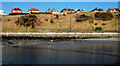
Elevated houses, Whitehead
Houses, in Donegall Avenue, with an uninterrupted view across Belfast Lough to the Copeland Islands.
Image: © Albert Bridge
Taken: 9 Mar 2010
0.11 miles
4
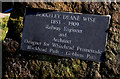
Berkeley Deane Wise plaque, Whitehead
Self-explanatory plaque near here Image commemorating Berkley Deane Wise architect and civil engineer to the Belfast and Northern Counties Railway. He also designed Carrickfergus station Image
Image: © Albert Bridge
Taken: 9 Mar 2010
0.12 miles
5
Whitehead Primary School
This image was taken from Islandmagee Road.
Image: © Eric Jones
Taken: 30 Jun 2017
0.12 miles
6
Whitehead to Blackhead (4)
Image: © Albert Bridge
Taken: 22 Feb 2008
0.12 miles
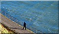
7
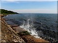
Splashing waves, Whitehead
Pictured along Old Castle Road
Image: © Kenneth Allen
Taken: 22 May 2012
0.14 miles
8
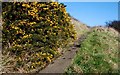
Whitehead to Blackhead (1)
There is a coastal footpath from the Banks at Whitehead near Image to the Blackhead lighthouse Image There is also an inland path quite close. Part of the inland path is said to be subject to subsidence and is fenced-off at the southern end. It is still used “at own risk”. The coastal path was closed, for a time, a few years ago after damage during rough weather. This is the inland path just after the start where it begins its ascent. Note: the inland path is not marked on the OS map. Continue to Image
Image: © Albert Bridge
Taken: 22 Feb 2008
0.14 miles
9
Whitehead to Blackhead (2)
Image: © Albert Bridge
Taken: 22 Feb 2008
0.14 miles
10
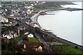
Whitehead from the Bla' Hole
View of Whitehead Town from the Bla' Hole
Image: © Wilson Adams
Taken: 22 Oct 2005
0.16 miles