IMAGES TAKEN NEAR TO
Donegall Rise, CARRICKFERGUS, BT38 9LN
Introduction
This page details the photographs taken nearby to Donegall Rise, BT38 9LN by members of the Geograph project.
The Geograph project started in 2005 with the aim of publishing, organising and preserving representative images for every square kilometre of Great Britain, Ireland and the Isle of Man.

There are currently over 7.5m images from over14,400 individuals and you can help contribute to the project by visiting https://www.geograph.org.uk
Image Map
Images are licensed for reuse under creativecommons.org/licenses/by-sa/2.0
Notes
- Clicking on the map will re-center to the selected point.
- The higher the marker number, the further away the image location is from the centre of the postcode.
Image Listing (13 Images Found)
Images are licensed for reuse under creativecommons.org/licenses/by-sa/2.0
Image
Details
Distance
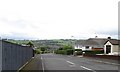
1

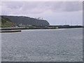
Donegall Rise, Whitehaven
The Cloughan oil jetty feeding Kilroot Power Station features prominently in the background. The headland on the right is White Head.
Image: © Eric Jones
Taken: 30 Jun 2017
0.06 miles
3
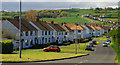
Garden Village, Whitehead (2)
See Image Another part of the development – at the north eastern end of the Islandmagee Road.
Image: © Albert Bridge
Taken: 3 May 2010
0.14 miles
4
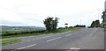
The junction of Ransevyn Drive and the B150
The B150 comes in from the right. It links at its western end with the A2 (Belfast Road)
Image: © Eric Jones
Taken: 30 Jun 2017
0.15 miles
5
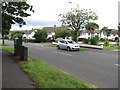
The Lumford Avenue junction on Ransevyn Drive
Image: © Eric Jones
Taken: 30 Jun 2017
0.16 miles
6
Clachan Rock Car Park.
This photo was taken from just inside the southern edge of the square looking towards Black Head Lighthouse.
Image: © Paul McIlroy
Taken: 22 Oct 2005
0.19 miles
7
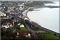
Whitehead from the Bla' Hole
View of Whitehead Town from the Bla' Hole
Image: © Wilson Adams
Taken: 22 Oct 2005
0.19 miles
9
McCrea's Brae, Whitehead (2013)
See Image (May 2010). The same view almost three years later with a Tesco home-delivery van descending.
Image: © Albert Bridge
Taken: 27 Apr 2013
0.23 miles
10
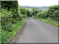
Descending the steep section of McCrea's Brae
Image: © Eric Jones
Taken: 30 Jun 2017
0.23 miles