IMAGES TAKEN NEAR TO
Paisley Road, CARRICKFERGUS, BT38 9AH
Introduction
This page details the photographs taken nearby to Paisley Road, BT38 9AH by members of the Geograph project.
The Geograph project started in 2005 with the aim of publishing, organising and preserving representative images for every square kilometre of Great Britain, Ireland and the Isle of Man.

There are currently over 7.5m images from over14,400 individuals and you can help contribute to the project by visiting https://www.geograph.org.uk
Image Map
Images are licensed for reuse under creativecommons.org/licenses/by-sa/2.0
Notes
- Clicking on the map will re-center to the selected point.
- The higher the marker number, the further away the image location is from the centre of the postcode.
Image Listing (2 Images Found)
Images are licensed for reuse under creativecommons.org/licenses/by-sa/2.0
Image
Details
Distance
1
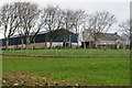
Paisley Road
Farmhouse and large barn on the Paisley Road.
Image: © Robert Ashby
Taken: 13 Apr 2014
0.23 miles
2
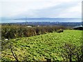
Middle Division Townland
A large townland (3868 acres) that encompasses most of the area to the immediate north of Carrickfergus. For whatever reason, the normal practice of dividing groups of farms into townlands never caught on in this area.
The view is towards Carrickfergus, Belfast Lough and North Down beyond that.
Taken from the Liberty Road.
Image: © Dean Molyneaux
Taken: 28 Feb 2010
0.24 miles