IMAGES TAKEN NEAR TO
North Road, CARRICKFERGUS, BT38 8LW
Introduction
This page details the photographs taken nearby to North Road, BT38 8LW by members of the Geograph project.
The Geograph project started in 2005 with the aim of publishing, organising and preserving representative images for every square kilometre of Great Britain, Ireland and the Isle of Man.

There are currently over 7.5m images from over14,400 individuals and you can help contribute to the project by visiting https://www.geograph.org.uk
Image Map
Images are licensed for reuse under creativecommons.org/licenses/by-sa/2.0
Notes
- Clicking on the map will re-center to the selected point.
- The higher the marker number, the further away the image location is from the centre of the postcode.
Image Listing (254 Images Found)
Images are licensed for reuse under creativecommons.org/licenses/by-sa/2.0
Image
Details
Distance
1
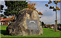
US Rangers memorial stone, Carrickfergus
A memorial stone (erected in 1992) on the North Road, at Sunnylands Avenue, commemorating the presence of the US Rangers at Sunnylands Camp during WWII. For an explanation in Image
Image: © Albert Bridge
Taken: 14 Oct 2011
0.02 miles
2
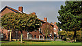
Fergus Avenue, Carrickfergus (2)
See Image The North Road end of the same street.
Image: © Albert Bridge
Taken: 1 Apr 2010
0.02 miles
3
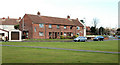
Rosebrook Grove, Carrickfergus
Part of the Sunnylands estate, facing the North Road.
Image: © Albert Bridge
Taken: 14 Oct 2011
0.05 miles
4
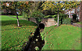
The Buskin Burn, Carrickfergus
The Buskin Burn rises to the north of Carrickfergus, near the Liberty Road. Much of its suburban course is culverted except for this short stretch at the North Road. It flows into the old mill ponds Image a short distance further to the east/south east.
Image: © Albert Bridge
Taken: 14 Oct 2011
0.05 miles
5
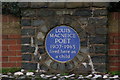
Louis Macneice plaque, Carrickfergus
The poet Louis Macneice lived in the North Road, Carrickfergus – his father was rector of St Nicholas's Church. The site is now occupied by sheltered housing. This plaque is at the entrance to the Macneice Fold. For more information see http://www.ulsterhistory.co.uk/louismcneice.htm. He was buried at Christ Church, Carrowdore Image See also Image (September 2013).
Image: © Albert Bridge
Taken: 30 Jan 2007
0.05 miles
7
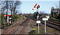
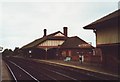
Somersault signals, Carrickfergus station
Somersault signals were the standard form of signalling for the ex-Northern Counties Committee lines of NIR (except Belfast York Road – Greenisland and Bleach Green Jct – Monkstown Image which had colour lights dating from the 1930’s and Larne Harbour Image with upper-quadrant semaphores). This is Larne end of Carrickfergus station with the down starter on the right and the down starting signal from the loop on the left. See also Image
Image: © Albert Bridge
Taken: 22 Apr 1984
0.07 miles
8
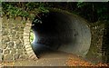
Railway bridge, Carrickfergus (2)
See Image There was (and still is) very limited space under the bridge in the previous photo for pedestrians passing on the eastern side. This subway was built (late 70’s if my memory is correct) to correct that deficiency. Continue to Image
Image: © Albert Bridge
Taken: 19 Sep 2009
0.07 miles
9
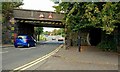
Railway bridge, Carrickfergus (1)
The bridge carries the Belfast (left) – Larne Harbour line across St Bride’s Street/the North Road. See also Image Image (July 2013) shows the bridge after rebuilding.
Image: © Albert Bridge
Taken: 19 Sep 2009
0.07 miles
10
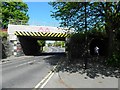
Low bridge, St Bride's Street
The road is heading north
Image: © Kenneth Allen
Taken: 28 Apr 2011
0.07 miles