IMAGES TAKEN NEAR TO
McKeens Green, CARRICKFERGUS, BT38 7TD
Introduction
This page details the photographs taken nearby to McKeens Green, BT38 7TD by members of the Geograph project.
The Geograph project started in 2005 with the aim of publishing, organising and preserving representative images for every square kilometre of Great Britain, Ireland and the Isle of Man.

There are currently over 7.5m images from over14,400 individuals and you can help contribute to the project by visiting https://www.geograph.org.uk
Image Map
Images are licensed for reuse under creativecommons.org/licenses/by-sa/2.0
Notes
- Clicking on the map will re-center to the selected point.
- The higher the marker number, the further away the image location is from the centre of the postcode.
Image Listing (218 Images Found)
Images are licensed for reuse under creativecommons.org/licenses/by-sa/2.0
Image
Details
Distance
1
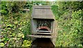
Widened railway bridge, Carrickfergus (1)
The stone part of the bridge dates from the opening of this part of the Belfast – Larne Harbour line by the Carrickfergus and Larne Railway in 1862. The concrete part was built by the LMS (NCC) when the line was doubled, to Whitehead, in 1929. The bridge is across the outlet from the old mill ponds Image See also Image
Image: © Albert Bridge
Taken: 19 Sep 2009
0.03 miles
2
Widened railway bridge, Carrickfergus (2)
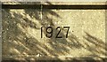
See Image The bridge carries the date “1927” suggesting that the contractor had completed the widened bridge well before the doubled line opened in 1929.
Image: © Albert Bridge
Taken: 19 Sep 2009
0.03 miles
3
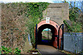
Railway bridge, Carrickfergus (3)
See Image Pedestrian bridge under the railway at Shaftesbury Park Image It leads to the old mill ponds Image In common with this one Image, it bears the date “1927”.
Image: © Albert Bridge
Taken: 1 Apr 2010
0.03 miles
4
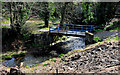
Footbridge, Carrickfergus (1)
A footbridge across the race leading from the old mill ponds Image Previously almost entirely hidden by vegetation. Continue to Image
Image: © Albert Bridge
Taken: 1 Apr 2010
0.03 miles
5
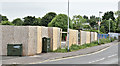
The Woodsides' site, Carrickfergus - June 2016(2)
The McKeen’s Avenue side of the site.
Image: © Albert Bridge
Taken: 5 Jun 2016
0.05 miles
6
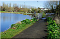
Footbridge, Carrickfergus (2)
Image: © Albert Bridge
Taken: 1 Apr 2010
0.06 miles
8
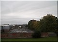
Railway renewal, Barn (2)
See Image Eight days later, the view towards, Carrickfergus and Belfast, where the new up line has been laid but is still without ballast. The 13.20 Whitehead – Belfast Central is passing “wrong line” on the down line. The old Taylor’s Avenue bridge Image is in the background. It was replaced by the present structure Image
Image: © Albert Bridge
Taken: 20 Apr 1997
0.07 miles
9
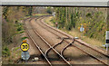
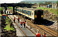
Railway crossover, Barn, Carrickfergus
A facing crossover, under this bridge Image, on the Carrickfergus side of the site of the former Barn station Image
Image: © Albert Bridge
Taken: 28 Nov 2013
0.07 miles
10
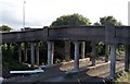
Old Bridge at Taylors Avenue
The original bridge at Taylors Avenue, constructed in concrete by the LMS/NCC in 1929
Image: © Wilson Adams
Taken: 1 Aug 2005
0.07 miles