IMAGES TAKEN NEAR TO
Trailcock Road, CARRICKFERGUS, BT38 7NU
Introduction
This page details the photographs taken nearby to Trailcock Road, BT38 7NU by members of the Geograph project.
The Geograph project started in 2005 with the aim of publishing, organising and preserving representative images for every square kilometre of Great Britain, Ireland and the Isle of Man.

There are currently over 7.5m images from over14,400 individuals and you can help contribute to the project by visiting https://www.geograph.org.uk
Image Map
Images are licensed for reuse under creativecommons.org/licenses/by-sa/2.0
Notes
- Clicking on the map will re-center to the selected point.
- The higher the marker number, the further away the image location is from the centre of the postcode.
Image Listing (5 Images Found)
Images are licensed for reuse under creativecommons.org/licenses/by-sa/2.0
Image
Details
Distance
1
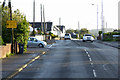
A2, Larne Road, between Carrickfergus and Kilroot
Image: © David Dixon
Taken: 29 Sep 2017
0.14 miles
2
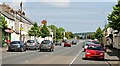
The Larne Road, Eden, Carrickfergus
Once a separate village (with its own railway station - now closed), Eden is now almost indistinguishable from Carrickfergus. The view is towards Larne.
Image: © Albert Bridge
Taken: 3 Jun 2009
0.14 miles
4
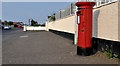
Pillar box, Eden, Carrickfergus
EIIR pillar box, on the Larne Road, outside Eden Primary School.
Image: © Albert Bridge
Taken: 22 Apr 2011
0.18 miles
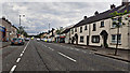
5
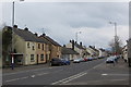
Eden village
Looking along the main street of the village of Eden towards Carrickfergus. It looks attractive but it straddles the busy A2 between Carrickfergus and Whitehead. Paradise and the Garden Of Eden don't readily spring to mind here nowadays.
Image: © Robert Ashby
Taken: 17 Mar 2014
0.25 miles