IMAGES TAKEN NEAR TO
Mill Close, CARRICKFERGUS, BT38 7FN
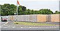
Introduction
This page details the photographs taken nearby to Mill Close, BT38 7FN by members of the Geograph project.
The Geograph project started in 2005 with the aim of publishing, organising and preserving representative images for every square kilometre of Great Britain, Ireland and the Isle of Man.

There are currently over 7.5m images from over14,400 individuals and you can help contribute to the project by visiting https://www.geograph.org.uk
Image Map
Images are licensed for reuse under creativecommons.org/licenses/by-sa/2.0
Notes
- Clicking on the map will re-center to the selected point.
- The higher the marker number, the further away the image location is from the centre of the postcode.
Image Listing (318 Images Found)
Images are licensed for reuse under creativecommons.org/licenses/by-sa/2.0
Image
Details
Distance
1
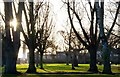
Shaftesbury Park, Carrickfergus (4)
See Image The view across the park towards the Marine Gardens.
Image: © Albert Bridge
Taken: 6 Jan 2008
0.02 miles
2
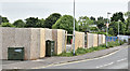
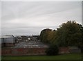
The Woodsides' site, Carrickfergus - June 2016(2)
The McKeen’s Avenue side of the site.
Image: © Albert Bridge
Taken: 5 Jun 2016
0.02 miles
3
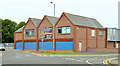
Former "Woodsides", Carrickfergus
Now long-closed, the former “Woodsides” at 30 Joymount is offered for sale on behalf of an insolvency practitioner. To the best of my knowledge this was the biggest of the six branches and incorporated a supermarket in addition to the usual clothes, hardware and “fancy goods”.
Image: © Albert Bridge
Taken: 10 Jul 2013
0.02 miles
4
Shaftesbury Park, Carrickfergus
Looking north-west
Image: © Kenneth Allen
Taken: 14 May 2010
0.02 miles
5
The Woodsides' site, Carrickfergus - June 2016(1)
Following demolition of the previous building the vacant site is currently surrounding by hoardings.
Image: © Albert Bridge
Taken: 5 Jun 2016
0.02 miles
6
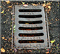
Phenix grating cover, Carrickfergus
Grating cover, at the Joymount end of Shaftesbury Park, cast by Wm Gregg, Sons & Phenix, the Union Foundry, Belfast.
Image: © Albert Bridge
Taken: 5 Sep 2010
0.03 miles
7
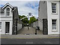
Entrance, Shaftesbury Park, Carrickfergus
It is located along Joymount
Image: © Kenneth Allen
Taken: 14 May 2010
0.03 miles
8
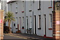
Robinson's Row, Carrickfergus
Robinson’s Row is an example of a disappearing breed – small terrace houses. It is a private street, owned by the Presbyterian Church, off Joymount, close to the library.
Image: © Albert Bridge
Taken: 14 Mar 2007
0.03 miles
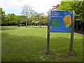
10
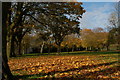
Shaftesbury Park, Carrickfergus
Shaftesbury Park lies between Joymount and the Belfast-Larne railway. It was built on land given to the town by Lord Shaftesbury.
Image: © Albert Bridge
Taken: 14 Nov 2006
0.04 miles