IMAGES TAKEN NEAR TO
Lancasterian Street, CARRICKFERGUS, BT38 7FH
Introduction
This page details the photographs taken nearby to Lancasterian Street, BT38 7FH by members of the Geograph project.
The Geograph project started in 2005 with the aim of publishing, organising and preserving representative images for every square kilometre of Great Britain, Ireland and the Isle of Man.

There are currently over 7.5m images from over14,400 individuals and you can help contribute to the project by visiting https://www.geograph.org.uk
Image Map
Images are licensed for reuse under creativecommons.org/licenses/by-sa/2.0
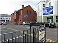
Notes
- Clicking on the map will re-center to the selected point.
- The higher the marker number, the further away the image location is from the centre of the postcode.
Image Listing (536 Images Found)
Images are licensed for reuse under creativecommons.org/licenses/by-sa/2.0
Image
Details
Distance
1
St Nicholas' Church Parish Halls, Carrickfergus
It is located at Albert Road
Image: © Kenneth Allen
Taken: 14 May 2010
0.01 miles
2
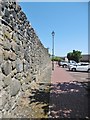
Carrickfergus, town wall
A fragment surviving on Lancasterian Street. The town walls were built 1608-15, making Carrickfergus is the oldest walled town in Ulster. https://www.midandeastantrim.gov.uk/tourism/things-to-do/history-heritage/carrickfergus-town-walls
Image: © Mike Faherty
Taken: 2 Jul 2018
0.02 miles
3
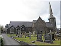
St Nicholas' Church of Ireland
A side view, looking south
Image: © Kenneth Allen
Taken: 14 May 2010
0.02 miles
4
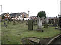
The graveyard of St Nicholas' Church, Carrickfergus
Image: © Eric Jones
Taken: 7 Aug 2012
0.03 miles
5
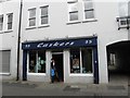
Caskers, Carrickfergus
It is located at West Street
Image: © Kenneth Allen
Taken: 14 May 2010
0.03 miles
6
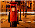
Pillar box, Carrickfergus
EIIR pillar box, at the corner of the Albert Road and West Street, partly lit by the passing traffic.
Image: © Albert Bridge
Taken: 1 Jan 2011
0.03 miles
7
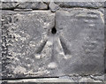
Bench Mark, Carrickfergus
Bolt bench mark (bolt removed though) near the door of St Nicholas's in Carrickfergus Image
This mark dates from the 1st levelling of Ireland which took place in 1839-43. The original remarks for the mark describe it as "Carrickfergus Church. Copper bolt driven into stonework at side of door; 2.6 feet above surface". It was initially levelled to 47.572 feet above sea level but has not appeared on recent maps.
Image: © Rossographer
Taken: 16 Jul 2015
0.03 miles
8
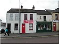
Barber Shop / Ophthalmic Optician, Carrickfergus
They are located at Lancasterian Street
Image: © Kenneth Allen
Taken: 14 May 2010
0.04 miles
9
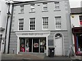
Shek Hair Group, Carrickfergus
It is located at West Street
Image: © Kenneth Allen
Taken: 14 May 2010
0.04 miles
10
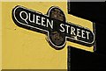
Street sign, Carrickfergus
The type of street sign used within the town centre.
Image: © Albert Bridge
Taken: 19 Sep 2009
0.04 miles