IMAGES TAKEN NEAR TO
Larne Road, CARRICKFERGUS, BT38 7DZ
Introduction
This page details the photographs taken nearby to Larne Road, BT38 7DZ by members of the Geograph project.
The Geograph project started in 2005 with the aim of publishing, organising and preserving representative images for every square kilometre of Great Britain, Ireland and the Isle of Man.

There are currently over 7.5m images from over14,400 individuals and you can help contribute to the project by visiting https://www.geograph.org.uk
Image Map
Images are licensed for reuse under creativecommons.org/licenses/by-sa/2.0
Notes
- Clicking on the map will re-center to the selected point.
- The higher the marker number, the further away the image location is from the centre of the postcode.
Image Listing (37 Images Found)
Images are licensed for reuse under creativecommons.org/licenses/by-sa/2.0
Image
Details
Distance
1
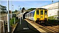
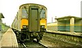
Departure from Downshire station
See Image The 10.27 from Larne Harbour departing Downshire for Belfast (Gt Victoria Street).
Image: © Albert Bridge
Taken: 11 Oct 2008
0.02 miles
2
Signal, Downshire station
This three-aspect colour-light signal is at the Belfast end of the up platform of Downshire station. It is displaying a green aspect showing that the line is clear to the signal after the next signal (ie two “sections”). It has two “feathers” which, when in use, display a single row of white lights. The upper indicates that the train is being routed, by a facing crossover, to platform 2 at Carrickfergus station. The lower is for platform 3.
Image: © Albert Bridge
Taken: 11 Oct 2008
0.02 miles
3
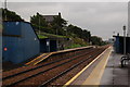
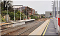
Downshire station, Carrickfergus (1)
Originally there were four stations between Carrickfergus and Whitehead. Only Downshire survives. Most of the traffic is to or from the Belfast direction. This is the view towards Whitehead and Larne.
Image: © Albert Bridge
Taken: 5 Sep 2006
0.02 miles
4
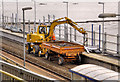
Rail/road crane, Downshire, Carrickfergus
A contractor’s Komatsu PW 110R rail/road crane at work on the provision of a new fence, on the up platform, at Downshire station Image There were no Translink trains or buses today during the UK-wide strike against proposed changes to public-sector pensions.
Image: © Albert Bridge
Taken: 30 Nov 2011
0.03 miles
5
Bridge demolition, Carrickfergus (2)
See Image A temporary railway timetable was in operation to accommodate the closure of the line between Carrickfergus and Downshire stations. Substitute buses operated between the two stations. The train is the 13.50 Downshire – Whitehead with single-line working over the down line. The lifted up line can be seen on the right. Continue to Image
Image: © Albert Bridge
Taken: 6 Apr 1997
0.03 miles
6
Downshire station, Carrickfergus (2)
Downshire station was closed for a few weeks to allow the platforms to be lengthened to accommodate new rolling stock. The station is open again but the entire line was closed today to facilitate work at Belfast York Road. Image shows the platforms before lengthening. See also Image
Image: © Albert Bridge
Taken: 9 Oct 2011
0.03 miles
7
Shelter, Downshire station
During the 70’s and 80’s NIR suffered badly from vandalism. Downshire station, being hidden from public view, received more than its fair share. This is the shelter on the up (Belfast-bound) platform. All changed now Image See also Image (April 1985).
Image: © Albert Bridge
Taken: 27 Jul 1985
0.04 miles
8
Train at Downshire
A British Rail built 80-class DEMU takes a Larne bound passenger service through a snowy Downshire Halt, east of Carrickfergus.
Image: © The Carlisle Kid
Taken: 21 Mar 1980
0.04 miles
9
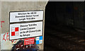
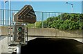
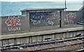
Tunnel sign, Downshire station
Self-explanatory warning sign at the entrance to the tunnel Image, under the Larne Road, at Downshire station. 78.65 metres works out at almost exactly 86 yards.
Image: © Albert Bridge
Taken: 20 Apr 2011
0.04 miles
10
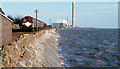
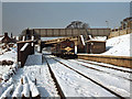
Train approaching Downshire station (February 1982)
See Image A similar view in 1982. A two-car DE set (72 and 701) close to Downshire station, about 55 minutes before high water, with the 13.30 Whitehead – Belfast York Road. The platforms have since been lengthened as seen in Image (October 2011).
Image: © Albert Bridge
Taken: 13 Feb 1982
0.04 miles