IMAGES TAKEN NEAR TO
Merville Garden Village, NEWTOWNABBEY, BT37 9TF
Introduction
This page details the photographs taken nearby to Merville Garden Village, BT37 9TF by members of the Geograph project.
The Geograph project started in 2005 with the aim of publishing, organising and preserving representative images for every square kilometre of Great Britain, Ireland and the Isle of Man.

There are currently over 7.5m images from over14,400 individuals and you can help contribute to the project by visiting https://www.geograph.org.uk
Image Map
Images are licensed for reuse under creativecommons.org/licenses/by-sa/2.0
Notes
- Clicking on the map will re-center to the selected point.
- The higher the marker number, the further away the image location is from the centre of the postcode.
Image Listing (53 Images Found)
Images are licensed for reuse under creativecommons.org/licenses/by-sa/2.0
Image
Details
Distance
1
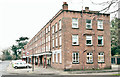
The Merville shops, Newtownabbey (January 2017)
The Merville shops, with flats above, facing the Shore Road.
Image: © Albert Bridge
Taken: 18 Jan 2017
0.02 miles
2
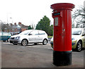
Pillar box, Merville, Newtownabbey
EIIR pillar box outside the shops at Merville Garden Village (on the Shore Road).
Image: © Albert Bridge
Taken: 16 Jan 2011
0.03 miles
3
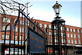
Lamp and fence, Merville, Newtownabbey
Ornamental fence and lamppost outside the shops at Merville Garden Village (on the Shore Road).
Image: © Albert Bridge
Taken: 16 Jan 2011
0.03 miles
4

Merville Garden Village, Newtownabbey - January 2017(2)
Flats, numbered 47-64 Merville Garden Village, in the area behind the shops. The architect would have been pleased to see how the trees matured.
Image: © Albert Bridge
Taken: 18 Jan 2017
0.04 miles
5
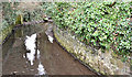
The Glas-na-Bradan, Whitehouse, Newtownabbey (January 2017)
The Glas-na-Bradan, looking upstream, seen from the bridge on the Shore Road, Whitehouse.
Image: © Albert Bridge
Taken: 18 Jan 2017
0.06 miles
6
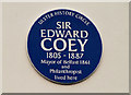
Coey plaque, Merville, Newtownabbey
Self-explanatory plaque, commemorating Sir Edward Coey http://www.ulsterhistory.co.uk/coey.htm, on Merville House the grounds of which became Merville Garden Village.
Image: © Albert Bridge
Taken: 16 Jan 2011
0.06 miles
7
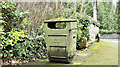
Litter bin, Whitehouse, Newtownabbey (January 2017)
A design of litter bin gradually being replaced by more modern versions. This one, with a coating of moss and green gunge, is at the Shore Road end of Whitehouse Park.
Image: © Albert Bridge
Taken: 18 Jan 2017
0.07 miles
8
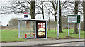
Bus shelter and road sign, Whitehouse, Newtownabbey (January 2017)
Bus shelter and direction sign on the Shore Road, opposite the Longwood Road. The stop is served by inward Metro and Ulsterbus services.
Image: © Albert Bridge
Taken: 18 Jan 2017
0.07 miles
9
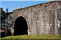
Railway bridge, Whitehouse (1)
A two-arch bridge carrying the Belfast – Londonderry and Larne Harbour lines. It probably dates from the building of the line as far as Greenisland in 1848. This span crosses the Glas-na-Bradan, a short river rising near Glengormley and entering Belfast Lough here via the Whitehouse Lagoon. See also Image
Image: © Albert Bridge
Taken: 15 Mar 2010
0.08 miles
10
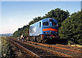
MV and PW train at Whitehouse, Newtownabbey
One of Northern Ireland Railways MV class diesel locomotives assists with rail recovery on the Belfast - Larne line at Whitehouse. For a shot of the same locomotive doing much the same thing at the same location - but in 1990 - see: Image]
Image: © The Carlisle Kid
Taken: 18 Jun 1989
0.08 miles