IMAGES TAKEN NEAR TO
Shore Road, NEWTOWNABBEY, BT37 9SB
Introduction
This page details the photographs taken nearby to Shore Road, BT37 9SB by members of the Geograph project.
The Geograph project started in 2005 with the aim of publishing, organising and preserving representative images for every square kilometre of Great Britain, Ireland and the Isle of Man.

There are currently over 7.5m images from over14,400 individuals and you can help contribute to the project by visiting https://www.geograph.org.uk
Image Map
Images are licensed for reuse under creativecommons.org/licenses/by-sa/2.0
Notes
- Clicking on the map will re-center to the selected point.
- The higher the marker number, the further away the image location is from the centre of the postcode.
Image Listing (22 Images Found)
Images are licensed for reuse under creativecommons.org/licenses/by-sa/2.0
Image
Details
Distance
1
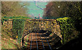
Railway bridge near Whiteabbey
Accommodation bridge, across the Belfast – Londonderry/Larne railway, to the south of Whiteabbey station. The yellow object, towards the lower left, is milepost 3¾.
Image: © Albert Bridge
Taken: 23 Mar 2011
0.12 miles
2
The Loughshore, Whiteabbey (6)
See Image Approaching Hazelbank, at 14.14, the low winter sun is casting long shadows.
Image: © Albert Bridge
Taken: 22 Dec 2007
0.12 miles
3
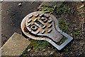
"GS" access cover, Whiteabbey
A small access cover, on the old section of the Shore Road Image, marked “GS”. The initials might mean “Geprüfte Sicherheit” (safety tested) 5007 equivalent to ISO 1083:2004 which defines the grades and the corresponding requirements for spheroidal graphite cast irons. Technical stuff picked up after much Googling.
Image: © Albert Bridge
Taken: 23 Mar 2011
0.14 miles
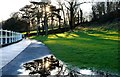
5
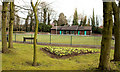
Bowling Green, Whiteabbey
The bowling green in Hazelbank Park. Used by Newtownabbey Bowls Club.
Image: © Albert Bridge
Taken: 15 Mar 2010
0.18 miles
6
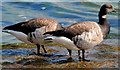
Geese, Belfast Lough
Pale-bellied Brent geese close to the western shore of Belfast Lough, at Whiteabbey. See also Image
Image: © Albert Bridge
Taken: 23 Mar 2011
0.20 miles
7
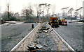
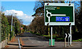
Building the M5 near Rushpark, Whiteabbey (3)
See Image Rushpark roundabout Image under construction on a murky day in December. Continue to Image
Image: © Albert Bridge
Taken: 9 Dec 1979
0.20 miles
8
Cycle path to Belfast
The cycle path which runs to Belfast city centre six miles down the coast.
Image: © Albert Thompson
Taken: 8 Feb 2009
0.20 miles
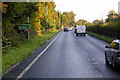
9
The old Shore Road, Rushpark, Newtownabbey
An abandoned section of the Shore Road (Abbeydale Close on the Google map), between the Rushpark and Station Road roundabouts, replaced by the dual carriageway seen in Image Still available to pedestrians. See also Image
Image: © Albert Bridge
Taken: 23 Mar 2011
0.21 miles
10
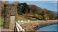
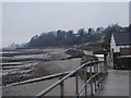
The loughshore path, Whiteabbey (1)
One of two stone structures, along the loughshore path, between Hazelbank and Whiteabbey. I have still not been able to find out who built them or why and when.
Image: © Albert Bridge
Taken: 23 Mar 2011
0.21 miles