IMAGES TAKEN NEAR TO
The Grange, NEWTOWNABBEY, BT37 0UJ
Introduction
This page details the photographs taken nearby to The Grange, BT37 0UJ by members of the Geograph project.
The Geograph project started in 2005 with the aim of publishing, organising and preserving representative images for every square kilometre of Great Britain, Ireland and the Isle of Man.

There are currently over 7.5m images from over14,400 individuals and you can help contribute to the project by visiting https://www.geograph.org.uk
Image Map
Images are licensed for reuse under creativecommons.org/licenses/by-sa/2.0
Notes
- Clicking on the map will re-center to the selected point.
- The higher the marker number, the further away the image location is from the centre of the postcode.
Image Listing (83 Images Found)
Images are licensed for reuse under creativecommons.org/licenses/by-sa/2.0
Image
Details
Distance
1
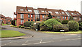
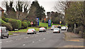
The Grange, Jordanstown, Newtownabbey
Houses on the north western side of the Shore Road (foreground). The grass and bushes mark the line reserved for the new road although, at the time of their construction, it was far from certain what form the road might take or that it would ever be built.
Image: © Albert Bridge
Taken: 16 Feb 2012
0.01 miles
2
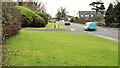
Reserved line, Jordanstown/Greenisland (1)
The Shore Road, at Jordanstown, looking towards Carrickfergus along the land reserved for the road widening. The entrance to The Grange Image is at middle left.
Image: © Albert Bridge
Taken: 16 Feb 2012
0.02 miles
3
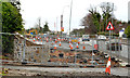
Road construction, Jordanstown (3)
Construction of the new road at The Grange, looking towards Carrickfergus, along what had been the reserved line.
Image: © Albert Bridge
Taken: 1 Dec 2013
0.02 miles
4
The Grange, Jordanstown (2013-1)
Starting to clear the reserved line at entrance to The Grange Image on the Shore Road. The view is towards Carrickfergus.
Image: © Albert Bridge
Taken: 4 May 2013
0.02 miles
5
The Shore Road, Jordanstown/Greenisland (1)
The end of the present four-lane stretch (looking towards Carrickfergus), at Jordanstown, of the Shore Road from Whiteabbey. Part of this turning circle Image is at bottom right. The Grange is towards the lower left. The reserved line is clearly visible to the left of the northbound traffic.
Image: © Albert Bridge
Taken: 16 Feb 2012
0.02 miles
6
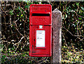
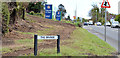
Letter box, Jordanstown
Post-mounted EIIR letter box, on the Shore Road, at this turning circle Image
Image: © Albert Bridge
Taken: 31 Mar 2011
0.03 miles
7
The Shore Road, Jordanstown/Greenisland (2)
The Shore Road immediately on the Belfast side of the entrance to the university Image This section will be dualled and part of the roundabout. The reserved line is in the foreground.
Image: © Albert Bridge
Taken: 16 Feb 2012
0.03 miles
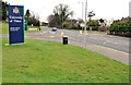
8
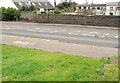
Bus stop and turning circle, Jordanstown
This bus stop, on the Shore Road, is used by the inward Carrickfergus/Greenisland – Belfast services. There is another (out of picture) in the turning circle used as a terminus by the Newtownabbey town service.
Image: © Albert Bridge
Taken: 31 Mar 2011
0.04 miles
9
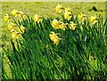
Daffodils, Jordanstown
See Image Part of the display this year to the north of the previous photo.
Image: © Albert Bridge
Taken: 12 Mar 2008
0.05 miles
10
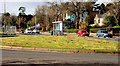
University entrance, Jordanstown, Newtownabbey (1)
The entrance, from the Shore Road, to the University of Ulster Image (looking towards Carrickfergus). This junction is due to become a roundabout and will be, to all intents and purposes, the start of the new road. The grassed area is the reserved line.
Image: © Albert Bridge
Taken: 16 Feb 2012
0.05 miles