IMAGES TAKEN NEAR TO
Wall Street, NEWTOWNABBEY, BT37 0TH
Introduction
This page details the photographs taken nearby to Wall Street, BT37 0TH by members of the Geograph project.
The Geograph project started in 2005 with the aim of publishing, organising and preserving representative images for every square kilometre of Great Britain, Ireland and the Isle of Man.

There are currently over 7.5m images from over14,400 individuals and you can help contribute to the project by visiting https://www.geograph.org.uk
Image Map
Images are licensed for reuse under creativecommons.org/licenses/by-sa/2.0
Notes
- Clicking on the map will re-center to the selected point.
- The higher the marker number, the further away the image location is from the centre of the postcode.
Image Listing (56 Images Found)
Images are licensed for reuse under creativecommons.org/licenses/by-sa/2.0
Image
Details
Distance
1
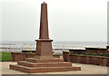
Whiteabbey war memorial (1)
Whiteabbey war memorial takes the form of an obelisk, in a small garden, by the shore of Belfast Lough. Image shows the inscription.
Image: © Albert Bridge
Taken: 15 Mar 2012
0.03 miles
2
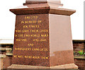
War memorial, Whiteabbey (2)
See Image The inscription on the landward side.
Image: © Albert Bridge
Taken: 15 Mar 2012
0.03 miles
3
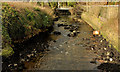
The Three Mile Water, Whiteabbey (1)
The end of the Three Mile Water, at the Shore Road, Whiteabbey. It enters Belfast Lough on the other side of the road. This is not part of the park but is included in the shared description for ease of reference.
Image: © Albert Bridge
Taken: 1 Feb 2012
0.03 miles
4
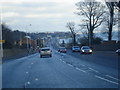
Shore Road to Whiteabbey
A view from the Shore Road driving towards Whiteabbey.
Image: © Albert Thompson
Taken: 28 Dec 2008
0.03 miles
5
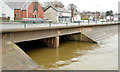
The Three Mile Water, Whiteabbey (5)
See Image The Three Mile Water, entering Belfast Lough, after flowing under the Shore Road. Continue to Image
Image: © Albert Bridge
Taken: 18 Feb 2014
0.03 miles
6
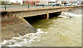
The Three Mile Water, Whiteabbey (March 2014)
See Image (February 2014). The same view today, about ten minutes after high water Belfast, as the river encounters a slightly breezy Belfast Lough.
Image: © Albert Bridge
Taken: 30 Mar 2014
0.03 miles
7
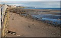
The Loughshore, Whiteabbey (1)
The shore of Belfast Lough is a prominent feature of this square. There is a loughshore path, passing through, which runs from Jordanstown to the Belfast harbour estate. The shore is a mixture of sand and rocks. This is the view towards Jordanstown from near the car park opposite Dillon’s Avenue.
Image: © Albert Bridge
Taken: 22 Dec 2007
0.05 miles
8
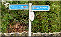
National Cycle Network signs, Whiteabbey
Signposts for National Cycle Network route 93 http://www.geograph.org.uk/tagged/National+cycle+route+93#photo=2739833 at the entrance to the Glen Park on the Glenville Road.
Image: © Albert Bridge
Taken: 18 Feb 2014
0.05 miles
9
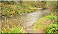
The Three Mile Water, Whiteabbey (4)
The Three Mile Water, almost at the end of its journey through the Glen Park, shortly before flowing under the Shore Road Image
Image: © Albert Bridge
Taken: 18 Feb 2014
0.06 miles
10
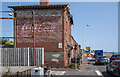
Old advert, Whiteabbey
Faded advert for Coca Cola on a gable wall at Whiteabbey. Previously seen in Image from 2007, it continues to survive.
Image: © Rossographer
Taken: 20 Jul 2021
0.07 miles