IMAGES TAKEN NEAR TO
Shore Road, NEWTOWNABBEY, BT37 0SP
Introduction
This page details the photographs taken nearby to Shore Road, BT37 0SP by members of the Geograph project.
The Geograph project started in 2005 with the aim of publishing, organising and preserving representative images for every square kilometre of Great Britain, Ireland and the Isle of Man.

There are currently over 7.5m images from over14,400 individuals and you can help contribute to the project by visiting https://www.geograph.org.uk
Image Map
Images are licensed for reuse under creativecommons.org/licenses/by-sa/2.0
Notes
- Clicking on the map will re-center to the selected point.
- The higher the marker number, the further away the image location is from the centre of the postcode.
Image Listing (63 Images Found)
Images are licensed for reuse under creativecommons.org/licenses/by-sa/2.0
Image
Details
Distance
1
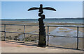
National Cycle Network Milepost, Whiteabbey
Milepost at Whiteabbey on Route 93.
Image: © Rossographer
Taken: 20 Jul 2021
0.02 miles
2
Loughshore path, Whiteabbey
A path runs along the shore of Belfast Lough, from Jordanstown, to near the northern side of Belfast harbour. This view is towards Whiteabbey village. The fence (left) is this one Image Knockagh war memorial Image is at top right.
Image: © Albert Bridge
Taken: 31 Aug 2010
0.02 miles
3
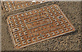
Clarksteel access cover, Whiteabbey
A Clarksteel access cover http://www.clark-drain.com/ and http://www.geograph.org.uk/search.php?i=29532952 , at the entrance to St James Court Image, on the Shore Road. It is marked “BCM Telecommunication” although this company http://www.bcm-tel.com/ does not seem to trade in the UK.
Image: © Albert Bridge
Taken: 15 Mar 2012
0.02 miles
4
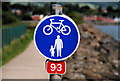
Cycle path sign, Whiteabbey
The loughshore path Image is shared between pedestrians and cyclists and is part of National Cycle Network route no 93.
Image: © Albert Bridge
Taken: 31 Aug 2010
0.04 miles
5
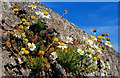
Sea mayweed, Whiteabbey
A flower usually associated with the shoreline Image and Image, seen growing from a wall close beside the loughshore path.
Image: © Albert Bridge
Taken: 31 Aug 2010
0.04 miles
6

National Cycle Network milepost, Whiteabbey
See Image (June 2008). The same milepost, on National Cycle Network route no 93 Image, by the loughshore at the Shore Road, Whiteabbey. Kilroot power station Image is in the background.
Image: © Albert Bridge
Taken: 29 May 2012
0.04 miles
7
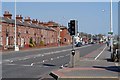
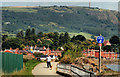
The Shore Road, Whiteabbey
The Shore Road at Whiteabbey looking towards Carrickfergus
Image: © Wilson Adams
Taken: 1 Apr 2007
0.04 miles
8
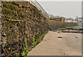
The seawall, Whiteabbey
The seawall which separates the Shore Road Image from Belfast Lough. It looks quite old but might only date from the reconstruction of the road in 1979/1980 Image
Image: © Albert Bridge
Taken: 15 Mar 2012
0.04 miles
9
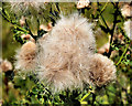
Thistles, Whiteabbey
Seeding thistles beside the loughshore path.
Image: © Albert Bridge
Taken: 31 Aug 2010
0.04 miles
10
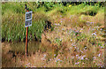
Damp ground, Whiteabbey (1)
An area on the western side of the loughshore path. It varies from very soft to flooded. This is the northern end with a bit of both on view. Continue to Image
Image: © Albert Bridge
Taken: 31 Aug 2010
0.05 miles