IMAGES TAKEN NEAR TO
Shore Road, NEWTOWNABBEY, BT37 0PZ
Introduction
This page details the photographs taken nearby to Shore Road, BT37 0PZ by members of the Geograph project.
The Geograph project started in 2005 with the aim of publishing, organising and preserving representative images for every square kilometre of Great Britain, Ireland and the Isle of Man.

There are currently over 7.5m images from over14,400 individuals and you can help contribute to the project by visiting https://www.geograph.org.uk
Image Map
Images are licensed for reuse under creativecommons.org/licenses/by-sa/2.0
Notes
- Clicking on the map will re-center to the selected point.
- The higher the marker number, the further away the image location is from the centre of the postcode.
Image Listing (99 Images Found)
Images are licensed for reuse under creativecommons.org/licenses/by-sa/2.0
Image
Details
Distance
1
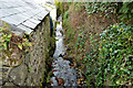
The Silverstream, Jordanstown/Greenisland
The seaward end of a short stream which flows under the Shore Road by the bridge seen in Image
Image: © Albert Bridge
Taken: 1 Dec 2013
0.04 miles
2
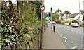
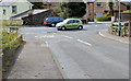
The Shore Road, Jordanstown/Greenisland (6)
The Shore Road (looking towards Carrickfergus) immediately past the entrance to Belfast High School Image, just before Silverstream Banks.
Image: © Albert Bridge
Taken: 16 Feb 2012
0.04 miles
3
Belfast High School, Jordanstown/Greenisland (2013-2)
Belfast High School at the entrance/exit on the Shore Road. Some trees have been removed (to the left of the gatepost).
Image: © Albert Bridge
Taken: 4 May 2013
0.04 miles
4
Silverstream Banks, Greenisland (2013-2)
Silverstream Banks, at the corner of the Shore Road where roadside vegetation has been removed. The area is on the right in Image The photograph also shows the bridge where the Silverstream passes under the road.
Image: © Albert Bridge
Taken: 4 May 2013
0.04 miles
5
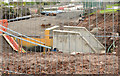
New culvert, Jordanstown/Greenisland
A new culvert being built at the end of Silverstream Banks. It will carry the Silverstream Image under the Shore Road and replace the existing bridge Image
Image: © Albert Bridge
Taken: 1 Dec 2013
0.04 miles
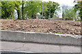
6
Silverstream Banks, Greenisland (2013-3)
Silverstream Banks Image looking down to the Shore Road. Roadside trees and vegetation have been removed on both sides.
Image: © Albert Bridge
Taken: 4 May 2013
0.04 miles
7
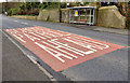
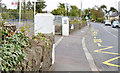
Road markings, Jordanstown
Road markings, for Belfast High Image, on the Carrickfergus side of the school. Crossing a busy dual carriageway will be an interesting undertaking. A possible case for “PUFFIN” lights Image?
Image: © Albert Bridge
Taken: 28 Feb 2012
0.04 miles
8
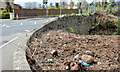
Silverstream Banks, Greenisland (1)
A small development of houses off the Shore Road (background). The area in the foreground will become part of the outward lanes of the new dual carriageway.
Image: © Albert Bridge
Taken: 16 Feb 2012
0.04 miles
9
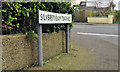
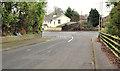
Silverstream Banks, Greenisland (3)
The name sign at the Shore Road end of Silverstream Banks Image
Image: © Albert Bridge
Taken: 16 Feb 2012
0.04 miles
10
Silverstream Banks, Greenisland (2013-1)
Silverstream Banks Image where the roadside trees have been removed. The view is towards Carrickfergus.
Image: © Albert Bridge
Taken: 4 May 2013
0.04 miles