IMAGES TAKEN NEAR TO
Jordanstown Road, NEWTOWNABBEY, BT37 0NU
Introduction
This page details the photographs taken nearby to Jordanstown Road, BT37 0NU by members of the Geograph project.
The Geograph project started in 2005 with the aim of publishing, organising and preserving representative images for every square kilometre of Great Britain, Ireland and the Isle of Man.

There are currently over 7.5m images from over14,400 individuals and you can help contribute to the project by visiting https://www.geograph.org.uk
Image Map
Images are licensed for reuse under creativecommons.org/licenses/by-sa/2.0
Notes
- Clicking on the map will re-center to the selected point.
- The higher the marker number, the further away the image location is from the centre of the postcode.
Image Listing (27 Images Found)
Images are licensed for reuse under creativecommons.org/licenses/by-sa/2.0
Image
Details
Distance
1
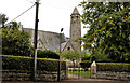
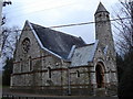
St Patrick's (CoI) church, Jordanstown (1)
Arguably one of the most attractive small churches in greater Belfast. St Patrick’s Church of Ireland , on the Jordanstown Road, was completed in 1868 to a design by WH Lynn of Lanyon, Lynn and Lanyon. In the Celtic revival style, it feature a sham round tower (73ft high). The church now sits, surrounded by trees, in an area of low-density suburbia. Previously seen in Image See also Image
Image: © Albert Bridge
Taken: 31 Aug 2011
0.03 miles
2
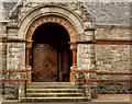
St Patrick's (CoI) church, Jordanstown (2)
See Image The doorway.
Image: © Albert Bridge
Taken: 31 Aug 2011
0.03 miles
3
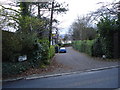
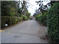
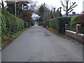
Sycamore Drive
Sycamore Drive opposite St Patrick's Church on the Jordanstown Road.
Image: © Albert Thompson
Taken: 2 Jan 2009
0.03 miles
4
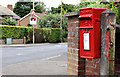
Letter box, Jordanstown
Post-mounted EIIR letter box at the corner of Lynda Avenue and the Jordanstown Road (background). The sign warning of Jordanstown level crossing Image is also visible.
Image: © Albert Bridge
Taken: 31 Aug 2011
0.08 miles
5
St Patrick's Church
St Patrick's Church (Church of Ireland) on the Jordanstown Road.
Image: © Albert Thompson
Taken: 2 Jan 2009
0.09 miles
6
Church Avenue
Church Avenue at the back of St Patrick's Church.
Image: © Albert Thompson
Taken: 2 Jan 2009
0.09 miles
7
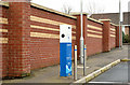
E-car charge point, Jordanstown
An E-car charge point at the railway park and ride car park, Lynda Avenue.
Image: © Albert Bridge
Taken: 30 Mar 2014
0.11 miles
8
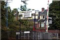
Station Entrance
Passenger exit/entrance on the Larne side of Jordanstown Station.
Image: © Wilson Adams
Taken: 28 Oct 2007
0.14 miles
9
Glenkeen Avenue
Glenkeen Avenue leading to Jordanstown Road
Image: © Albert Thompson
Taken: 2 Jan 2009
0.14 miles
10
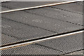
Track damping system, Jordanstown level crossing
“Strail” track damping in use on the level crossing Image at Jordanstown station. Read all about it here http://www.strail.de/index.php?id=5&L=1
Image: © Albert Bridge
Taken: 31 Aug 2011
0.15 miles