IMAGES TAKEN NEAR TO
Abbey Court, NEWTOWNABBEY, BT37 0AP
Introduction
This page details the photographs taken nearby to Abbey Court, BT37 0AP by members of the Geograph project.
The Geograph project started in 2005 with the aim of publishing, organising and preserving representative images for every square kilometre of Great Britain, Ireland and the Isle of Man.

There are currently over 7.5m images from over14,400 individuals and you can help contribute to the project by visiting https://www.geograph.org.uk
Image Map
Images are licensed for reuse under creativecommons.org/licenses/by-sa/2.0
Notes
- Clicking on the map will re-center to the selected point.
- The higher the marker number, the further away the image location is from the centre of the postcode.
Image Listing (42 Images Found)
Images are licensed for reuse under creativecommons.org/licenses/by-sa/2.0
Image
Details
Distance
1
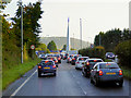
The A2 at Whiteabbey
Approaching the Station Road roundabout with its distinctive obelisk/sculpture (see Image]).
Image: © David Dixon
Taken: 29 Sep 2017
0.06 miles
2
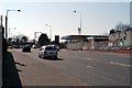
Shore Road, Whiteabbey
Vehicles approaching Whiteabbey Roundabout.
Image: © Wilson Adams
Taken: 1 Apr 2007
0.06 miles
3
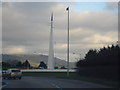
Roundabout linking the A2 to the Shore Road
The monument at the roundabout linking the A2 to the Shore Road. This depicts the monks pointed hat in blue (Whiteabbey) and the white arrows the sails of a yacht.
Image: © Albert Thompson
Taken: 28 Dec 2008
0.08 miles
4
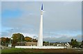
Thingamajig MkII, Whiteabbey
See Image The white heat of thingamajig technology is moving quickly. This MKII version is on the Station Road roundabout, at Whiteabbey, on the Belfast – Carrickfergus road.
Image: © Albert Bridge
Taken: 17 Oct 2008
0.09 miles
5
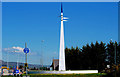
Roundabout sculpture, Whiteabbey
A sunnier look at the sculpture previously seen in Image For the record it is described in the Newtownabbey Borough Council website as “Designed as part of an ongoing environmental improvement scheme, the sculpture aims to create a sense of place when entering Whiteabbey. The landmark sculpture represents the famous maritime heritage of Whiteabbey and is also inspired by the monks who wore white robes at the local abbey. Blue was chosen for the beacon colour as it is commonly used to signify truth and security. The wind vanes show the changing wind direction which would have been important to shipping and sailing. Designed by the Landscape designer and Sculptor Stephen Todd who was responsible for landmark sculptures in Coleraine, Manchester and York. He has also been commissioned to create a landmark in Dubai.”
Image: © Albert Bridge
Taken: 23 Mar 2011
0.09 miles
6
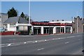
Car Showrooms
S.S. Logan's, car showrooms near the roundabout on the Shore Road, Whiteabbey.
Image: © Wilson Adams
Taken: 1 Apr 2007
0.10 miles
7
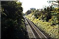
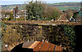
The Cutting
Image made from an overbridge at Station Road Whiteabbey, looking towards Belfast. The bridge in the distance is a pedestrian bridge. The A2 Shore Road to Belfast runs parallel to the railway line, and the Hi-rise flats are located at Rush Park.
Image: © Wilson Adams
Taken: 28 Oct 2007
0.11 miles
8
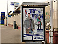
"New trains" poster, Whiteabbey
A poster, on a bus stop on the Shore road, advertising the introduction of the new trains on the Larne line Image
Image: © Albert Bridge
Taken: 15 Mar 2012
0.12 miles
9
Railway bridge, Whiteabbey station
The bridge carrying the (old) Station Road across the Londonderry/Larne railway at Whiteabbey station. Still open to local vehicular traffic, it was replaced (for most purposes) by the four-lane concrete bridge on which I am standing. Image shows the bridge from platform level (March 2012). The oval plate, bottom left, is the bridge number (13).
Image: © Albert Bridge
Taken: 23 Mar 2011
0.13 miles
10
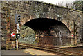
Bridge, Whiteabbey station
This bridge, at the Belfast end of Whiteabbey station, carries the old alignment of the Station Road (Ypres Park on the Google map) across the railway. It can be seen, from the new alignment, in Image (March 2011).
Image: © Albert Bridge
Taken: 15 Mar 2012
0.13 miles