IMAGES TAKEN NEAR TO
Glenwell Grove, NEWTOWNABBEY, BT36 7TB
Introduction
This page details the photographs taken nearby to Glenwell Grove, BT36 7TB by members of the Geograph project.
The Geograph project started in 2005 with the aim of publishing, organising and preserving representative images for every square kilometre of Great Britain, Ireland and the Isle of Man.

There are currently over 7.5m images from over14,400 individuals and you can help contribute to the project by visiting https://www.geograph.org.uk
Image Map
Images are licensed for reuse under creativecommons.org/licenses/by-sa/2.0
Notes
- Clicking on the map will re-center to the selected point.
- The higher the marker number, the further away the image location is from the centre of the postcode.
Image Listing (3 Images Found)
Images are licensed for reuse under creativecommons.org/licenses/by-sa/2.0
Image
Details
Distance
1
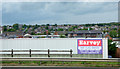
Glengormley from the M2 motorway
A wide range of building types and architectural styles on view here.
Image: © Thomas Nugent
Taken: 1 Jun 2019
0.19 miles
2
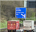
Advance direction sign, M2 hill section, Belfast (March 2017)
Advance direction sign, for the Sandyknowes turnoff Image, beside the outward lanes of the M2, seen from the Bellevue Bridge on the Antrim Road.
Image: © Albert Bridge
Taken: 23 Mar 2017
0.24 miles
3
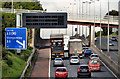
The M2 hill section, Bellevue, Newtownabbey
See Image The outward view, from the Bellevue Bridge, towards Sandyknowes. The Collin Bridge (background) was rebuilt with a very high fence making photography there next to impossible. The Belfast/Newtownabbey boundary is immediately on the Belfast side of the Bellevue Bridge.
Image: © Albert Bridge
Taken: 28 Sep 2012
0.25 miles