IMAGES TAKEN NEAR TO
Whitewell Road, NEWTOWNABBEY, BT36 7RY
Introduction
This page details the photographs taken nearby to Whitewell Road, BT36 7RY by members of the Geograph project.
The Geograph project started in 2005 with the aim of publishing, organising and preserving representative images for every square kilometre of Great Britain, Ireland and the Isle of Man.

There are currently over 7.5m images from over14,400 individuals and you can help contribute to the project by visiting https://www.geograph.org.uk
Image Map
Images are licensed for reuse under creativecommons.org/licenses/by-sa/2.0
Notes
- Clicking on the map will re-center to the selected point.
- The higher the marker number, the further away the image location is from the centre of the postcode.
Image Listing (13 Images Found)
Images are licensed for reuse under creativecommons.org/licenses/by-sa/2.0
Image
Details
Distance
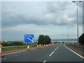
1
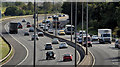
The M2 hill section, Bellevue, Belfast
The view, towards the centre of Belfast, from the Bellevue Bridge on the Antrim Road. This section of the motorway has a maximum gradient of 1 in 15 making the third lane very useful for loaded lorries. The Ulsterbus “Goldline” express (middle right) had little difficulty in making the climb and was overtaking in the middle lane. Image shows the view in the other direction.
Image: © Albert Bridge
Taken: 28 Sep 2012
0.05 miles
2

Former trolleybus turning circle, Bellevue, Belfast (2)
See Image A close look at the setts.
Image: © Albert Bridge
Taken: 28 Sep 2012
0.09 miles
3
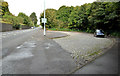
Former trolleybus turning circle, Bellevue, Belfast (1)
See Image The last Belfast trolleybus ran on 12 May 1968. Although the route extended to Glengormley some, on the Bellevue service, terminated at this turning circle (still paved with setts- see Image) on the eastern side of the Antrim Road. The recess in the zoo wall (upper left) was to allow a safe spot for passengers using the stop on that side of the road. Image shows the one at Strathmore Park.
Image: © Albert Bridge
Taken: 28 Sep 2012
0.09 miles
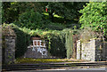
4
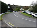
Entrance drive to Belfast Zoo
Heading south up the steep hill
Image: © Kenneth Allen
Taken: 3 May 2010
0.11 miles
5
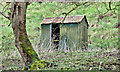
Old hut, Bellevue, Belfast (March 2017)
The remains of an old corrugated metal hut, in the grounds of Belfast Zoo, seen from the Antrim Road.
Image: © Albert Bridge
Taken: 23 Mar 2017
0.12 miles
6
Junction 2 on the M2 Approaching
Belfast Lough is visible in the distance.
Image: © Ian Paterson
Taken: 24 Jul 2007
0.12 miles
7
Former zoo entrance, Belfast
A now-disused entrance, at a badly-sighted spot on the Antrim Road, opposite Floral Gardens. The name “Bellevue” has not been removed explaining why Belfast Zoo is still sometimes locally called “Bellevue Zoo”.
Image: © Albert Bridge
Taken: 28 Sep 2012
0.14 miles
8
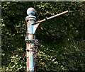
Old trolleybus pole, Belfast
A surprising survivor, close to Image on the Antrim Road. The last Belfast trolleybus ran on 12 May 1968. The knob on the top and the bracket are the clues.
Image: © Albert Bridge
Taken: 28 Sep 2012
0.14 miles
9
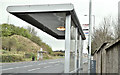
Bus stops and shelters, Antrim Road, Belfast (March 2017)
Inward (foreground) and outward bus stops and shelters on the Antrim Road. The M2 Bellevue Bridge is in the background.
Image: © Albert Bridge
Taken: 23 Mar 2017
0.16 miles
10
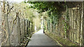
Floral Lane, Belfast (March 2017)
A short path running from the Antrim Road to the Whitewell Road (background). It looks very tranquil but the sound of the M2 Image (below the fence on the left) is very intrusive.
Image: © Albert Bridge
Taken: 23 Mar 2017
0.16 miles