IMAGES TAKEN NEAR TO
Mill Road, NEWTOWNABBEY, BT36 7BE
Introduction
This page details the photographs taken nearby to Mill Road, BT36 7BE by members of the Geograph project.
The Geograph project started in 2005 with the aim of publishing, organising and preserving representative images for every square kilometre of Great Britain, Ireland and the Isle of Man.

There are currently over 7.5m images from over14,400 individuals and you can help contribute to the project by visiting https://www.geograph.org.uk
Image Map
Images are licensed for reuse under creativecommons.org/licenses/by-sa/2.0
Notes
- Clicking on the map will re-center to the selected point.
- The higher the marker number, the further away the image location is from the centre of the postcode.
Image Listing (8 Images Found)
Images are licensed for reuse under creativecommons.org/licenses/by-sa/2.0
Image
Details
Distance
1
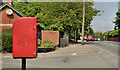
Letter box, Felden, Newtownabbey
Post-mounted EIIR letter box (BT36 285), at Old Mill Drive on the Mill Road, close to the former Felden Mill and Skills Centre.
Image: © Albert Bridge
Taken: 25 May 2012
0.10 miles
2
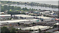
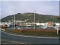
The Longlands Retail Park, Newtownabbey
One of three shopping centres/retail parks, convenient to the M2 at Greencastle, off the Mill Road. Whitehouse lagoon http://www.geograph.org.uk/snippet/4772 and the M5 Image are at the top of the photograph. The view is from the grounds of the Belfast Castle estate.
Image: © Albert Bridge
Taken: 6 Jun 2012
0.15 miles
3
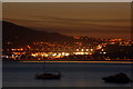
Sunset over Belfast Lough
Whitehouse is a suburb of Belfast between Fortwilliam and Whiteabbey. It is probably best known for the Abbeycentre shopping centre and the adjacent “retail park”. This is Whitehouse just after sunset as seen from Holywood on the other side of Belfast Lough. The streak of white light running from upper right to middle left is the hill section of the M2. The streak of red, green and white light at water level is one of the Belfast harbour pilot launches.
Image: © Albert Bridge
Taken: 15 Sep 2006
0.19 miles
4
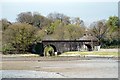
A Railway Bridge
A railway bridge that carries the railway line to Larne and Londonderry across the Glas-na-Bradan River (left) and a road named Whitehouse Park (right) that leads to Whitehouse Park.
The watery area directly in front of the photographer is Whitehouse Lagoon, previously Belfast Lough. This was before the M5 Motorway was constructed.
Image: © Wilson Adams
Taken: 9 Apr 2007
0.19 miles
5
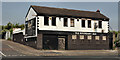
Former Boundary Bar, Greencastle, Newtownabbey
Now disused and blocked up bar, on the Shore Road, on the outward side of the flyover (right background in Image). The present boundary, between Belfast and Newtownabbey is out of picture to the left. At one time the boundary was between the City of Belfast and Belfast No1 Rural District. For a later view see Image
Image: © Albert Bridge
Taken: 25 May 2012
0.22 miles
6
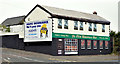
The disguised former "Boundary Bar", Greencastle, Newtownabbey (September 2014)
See Image (May 2012). This long-derelict former bar, on the Shore Road, was one of the many buildings disguised for the passing of the Giro d'Italia bicycle race http://www.geograph.org.uk/snippet/10822 earlier this year.
Image: © Albert Bridge
Taken: 19 Sep 2014
0.22 miles
7
Retail Park
At Whiteabbey with The Cave Hill in the background.Image
Image: © Paul McIlroy
Taken: 13 Apr 2006
0.23 miles
8
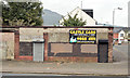
Derelict buildings, Greencastle, Newtownabbey (September 2014)
Derelict former shops, on the Shore Road, at the corner of Mount Street (right) across from Image
Image: © Albert Bridge
Taken: 19 Sep 2014
0.24 miles