IMAGES TAKEN NEAR TO
Planting Road, NEWRY, BT35 9YH
Introduction
This page details the photographs taken nearby to Planting Road, BT35 9YH by members of the Geograph project.
The Geograph project started in 2005 with the aim of publishing, organising and preserving representative images for every square kilometre of Great Britain, Ireland and the Isle of Man.

There are currently over 7.5m images from over14,400 individuals and you can help contribute to the project by visiting https://www.geograph.org.uk
Image Map
Images are licensed for reuse under creativecommons.org/licenses/by-sa/2.0
Notes
- Clicking on the map will re-center to the selected point.
- The higher the marker number, the further away the image location is from the centre of the postcode.
Image Listing (6 Images Found)
Images are licensed for reuse under creativecommons.org/licenses/by-sa/2.0
Image
Details
Distance
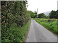
1
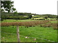
Houses on the ascending Planting Road
Planting Road rounds the northern end of Cashel hill. This image was taken across damp valley floor land from the Ballinasack Road.
Image: © Eric Jones
Taken: 2 Sep 2014
0.04 miles
2
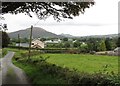
Approaching the junction at Ballinasack Road
The road running right links with the Tullymacreeve Road. The one on the left - Planting Road doubles back over the northern shoulder of Cashel hill to rejoin Cashel Road.
Image: © Eric Jones
Taken: 2 Sep 2014
0.15 miles
3
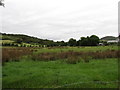
The flood plain of the Forkhill River north of Ballinasack Road
Image: © Eric Jones
Taken: 2 Sep 2014
0.18 miles
4
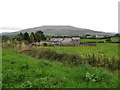
Renovated traditional cottage off the Ballinasack Road
The western face of Slieve Gullion forms the background.
Image: © Eric Jones
Taken: 2 Sep 2014
0.18 miles
5
Ballinasack Road approaching the junction with Tullymacreeve Road
Image: © Eric Jones
Taken: 2 Sep 2014
0.22 miles
6
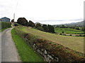
Harvested hay field below Ballinasack Road
Image: © Eric Jones
Taken: 2 Sep 2014
0.24 miles