IMAGES TAKEN NEAR TO
Main Street, NEWRY, BT35 9SG
Introduction
This page details the photographs taken nearby to Main Street, BT35 9SG by members of the Geograph project.
The Geograph project started in 2005 with the aim of publishing, organising and preserving representative images for every square kilometre of Great Britain, Ireland and the Isle of Man.

There are currently over 7.5m images from over14,400 individuals and you can help contribute to the project by visiting https://www.geograph.org.uk
Image Map
Images are licensed for reuse under creativecommons.org/licenses/by-sa/2.0
Notes
- Clicking on the map will re-center to the selected point.
- The higher the marker number, the further away the image location is from the centre of the postcode.
Image Listing (116 Images Found)
Images are licensed for reuse under creativecommons.org/licenses/by-sa/2.0
Image
Details
Distance
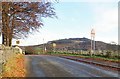
1
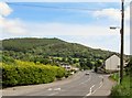
Entering Forkhill from the North along Church Road
The forested Tievecrom hill forms the background.
Image: © Eric Jones
Taken: 20 Jun 2012
0.03 miles
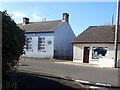
2
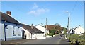
The northern end of School Road, Forkhill
The blue painted building on the left is the old St Oliver Plunkett National School now replaced by a modern building on the south side of the village.
Image]
Image: © Eric Jones
Taken: 17 Oct 2018
0.04 miles
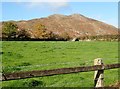
3
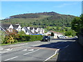
Modern houses in Church Road, Forkhill
Across the Forkill Valley is the wooded Tievecrom hill which during the Troubles was the site of British Army watchtower Romeo 23.
Image: © Eric Jones
Taken: 14 May 2019
0.05 miles
4
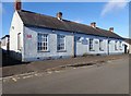
Scoil N?isi?nta Fhoirceala - Forkhill National School
The "Living in History guide to Forkhill and Mullaghbawn" published by the Ring of Gullion.org says of this building on School Road: "It was started in 1856; the principal was James Kirk who was just 21 years old. He taught 40 children in one room measuring just fifteen by thirteen feet. The school is now a vacant building and the school has moved to a modern purpose built building Image] but is still named for St Oliver Plunkett as the original school was."
Image: © Eric Jones
Taken: 17 Oct 2018
0.05 miles
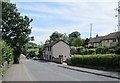
5
Shop near the former Forkhill St Oliver's National School
Image: © Eric Jones
Taken: 17 Oct 2018
0.06 miles
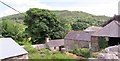
8
Paddock at the Northern end of School Road, Forkhill
Crosslieve forms the background. This is a remnant of a volcanic vent.
Image: © Eric Jones
Taken: 17 Oct 2018
0.10 miles
9
The Bog Road approaching its junction with Church Road. Forkhill
The mountain in the background is Tievecom, formerly the site of British Army Watchtower Romeo 23. The link is to the view of Forkhill from Romeo 23 captured by a Magnumphotos photographer and
published in the Guardian. It shows, on the right hand side, the Bog Road/Church Road junction.
https://www.theguardian.com/uk-news/2017/apr/15/brexit-northern-irish-border#img-10
Image: © Eric Jones
Taken: 29 Oct 2018
0.10 miles
10
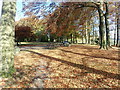
The Plantin, Forkhill
The Plantin was a garden designed in 1839 by Richard Jackson, the local squire, as a token of his love for his wife. It is now a public park. Viewed from the surrounding hills, the trees in The Plantin form a heart shape arrangement.
Image: © Eric Jones
Taken: 17 Oct 2018
0.11 miles