IMAGES TAKEN NEAR TO
Lough Road, NEWRY, BT35 9NR
Introduction
This page details the photographs taken nearby to Lough Road, BT35 9NR by members of the Geograph project.
The Geograph project started in 2005 with the aim of publishing, organising and preserving representative images for every square kilometre of Great Britain, Ireland and the Isle of Man.

There are currently over 7.5m images from over14,400 individuals and you can help contribute to the project by visiting https://www.geograph.org.uk
Image Map
Images are licensed for reuse under creativecommons.org/licenses/by-sa/2.0
Notes
- Clicking on the map will re-center to the selected point.
- The higher the marker number, the further away the image location is from the centre of the postcode.
Image Listing (1 Images Found)
Images are licensed for reuse under creativecommons.org/licenses/by-sa/2.0
Image
Details
Distance
1
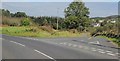
The Lough Road junction on the B30 (Silverbridge Road)
The area around Lough Road is heavily glaciated with ice carved lakes and bare rock outcrops. There are considerable tracts of heathland and conifer forests.
Image: © Eric Jones
Taken: 18 Sep 2019
0.24 miles