IMAGES TAKEN NEAR TO
Cortreasla Road, NEWRY, BT35 9LZ
Introduction
This page details the photographs taken nearby to Cortreasla Road, BT35 9LZ by members of the Geograph project.
The Geograph project started in 2005 with the aim of publishing, organising and preserving representative images for every square kilometre of Great Britain, Ireland and the Isle of Man.

There are currently over 7.5m images from over14,400 individuals and you can help contribute to the project by visiting https://www.geograph.org.uk
Image Map
Images are licensed for reuse under creativecommons.org/licenses/by-sa/2.0
Notes
- Clicking on the map will re-center to the selected point.
- The higher the marker number, the further away the image location is from the centre of the postcode.
Image Listing (8 Images Found)
Images are licensed for reuse under creativecommons.org/licenses/by-sa/2.0
Image
Details
Distance
1
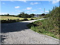
Private lane linking houses to the Cortreasla Road
Image: © Eric Jones
Taken: 10 Sep 2014
0.07 miles
2
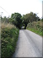
View along Cortreasla Road west of the junction with Carnally Road
Image: © Eric Jones
Taken: 10 Sep 2014
0.15 miles
3
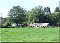
Traditional homestead buildings off Carnally Road
Image: © Eric Jones
Taken: 10 Sep 2014
0.18 miles
4
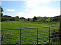
Drained wetland on the east side of Cortreasla Road
This is an area of rock outcrops and wet hollows.
Image: © Eric Jones
Taken: 10 Sep 2014
0.18 miles
5
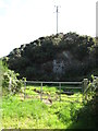
Disused quarry on the south side of Cortreasla Road
Image: © Eric Jones
Taken: 10 Sep 2014
0.22 miles
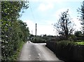
6
View north along Carnally Road from its junction with Cortreasla Road
Image: © Eric Jones
Taken: 10 Sep 2014
0.23 miles
7
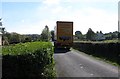
Delivery lorry on the narrow Carnally Road
Image: © Eric Jones
Taken: 10 Sep 2014
0.23 miles
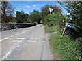
8
Carnally Road at its junction with Cortreasla Road
Cortreasla Road proceeds southwards for a hundred metres or so before turning north-eastwards at the entrance to a stone quarry and proceeding in the direction of the A29.
Image: © Eric Jones
Taken: 10 Sep 2014
0.23 miles