IMAGES TAKEN NEAR TO
Newry Road, NEWRY, BT35 9ES
Introduction
This page details the photographs taken nearby to Newry Road, BT35 9ES by members of the Geograph project.
The Geograph project started in 2005 with the aim of publishing, organising and preserving representative images for every square kilometre of Great Britain, Ireland and the Isle of Man.

There are currently over 7.5m images from over14,400 individuals and you can help contribute to the project by visiting https://www.geograph.org.uk
Image Map
Images are licensed for reuse under creativecommons.org/licenses/by-sa/2.0
Notes
- Clicking on the map will re-center to the selected point.
- The higher the marker number, the further away the image location is from the centre of the postcode.
Image Listing (13 Images Found)
Images are licensed for reuse under creativecommons.org/licenses/by-sa/2.0
Image
Details
Distance
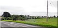
1
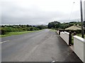
View East along the B30 (Newry Road)
The image was taken from the front of O'Neill Estate.
Image: © Eric Jones
Taken: 21 Aug 2018
0.15 miles
2
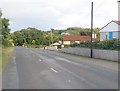
The B30 passing O'Neill's Estate
This is located between Creggan and Silverbridge.
Image: © Eric Jones
Taken: 28 Aug 2019
0.15 miles
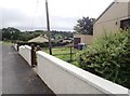
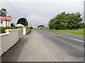
3
O'Neills Estate
This is located on the south side of the B30 between Creggan and Silverbridge.
Image: © Eric Jones
Taken: 28 Aug 2019
0.15 miles
4
The O'Neill Estate on the B30 (Newry Road)
This estate of bungalows stands on the south side of the B30 about a mile east of the village of Creggan.
Image: © Eric Jones
Taken: 21 Aug 2018
0.16 miles
5
Farmland on the south-eastern side of the B 30 (Newry Road)
Image: © Eric Jones
Taken: 21 Aug 2018
0.18 miles
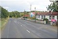
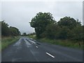
6
View West along the B30 (Newry Road)
The B30 links Newry and Crossmaglen. The houses on the left are on the O'Neill Estate.
Image: © Eric Jones
Taken: 21 Aug 2018
0.18 miles
7
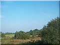
Wetland seen from the B30 east of Creggan
Image: © Eric Jones
Taken: 11 Sep 2014
0.22 miles
8
Bus shelters at the Cregganduff Road junction on the B30
These shelters are primarily for the use of children waiting for school buses.
Image: © Eric Jones
Taken: 21 Aug 2018
0.23 miles
9
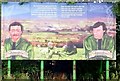
Republican hoarding near Cregganduff Road junction on the B30
This area is in the heart of Republican South Armagh. It is an area which includes Creggan, Crossmaglen and Cullyhanna. Burns and Moley were killed when a 300lb bomb they were transporting blew up prematurely.
https://www.upi.com/Archives/1988/03/02/IRAs-top-fugitive-killed-in-bomb-blast/2239573282000/
Image: © Eric Jones
Taken: 21 Aug 2018
0.24 miles
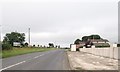
10
The B30 (Newry Road) approaching the junction with Lurgan Road
Image: © Eric Jones
Taken: 21 Aug 2013
0.24 miles