IMAGES TAKEN NEAR TO
Loughaveely Road, NEWRY, BT35 9EN
Introduction
This page details the photographs taken nearby to Loughaveely Road, BT35 9EN by members of the Geograph project.
The Geograph project started in 2005 with the aim of publishing, organising and preserving representative images for every square kilometre of Great Britain, Ireland and the Isle of Man.

There are currently over 7.5m images from over14,400 individuals and you can help contribute to the project by visiting https://www.geograph.org.uk
Image Map
Images are licensed for reuse under creativecommons.org/licenses/by-sa/2.0
Notes
- Clicking on the map will re-center to the selected point.
- The higher the marker number, the further away the image location is from the centre of the postcode.
Image Listing (22 Images Found)
Images are licensed for reuse under creativecommons.org/licenses/by-sa/2.0
Image
Details
Distance
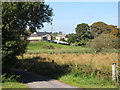
1
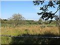
View east across Loughaveely Fen towards Glasdrumman Chapel and the Castlerock Estate
This area east of the road is part of 4.74 ha fen and also contains a number of former peat workings.
http://www.doeni.gov.uk/niea/protected_areas_home/new_assi_landing_page/county_armagh-2/loughaveely_assi.htm
Image: © Eric Jones
Taken: 10 Sep 2014
0.10 miles
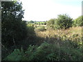
2
Grazing land between rock outcrops south of the Loughaveely Bog
Image: © Eric Jones
Taken: 10 Sep 2014
0.12 miles
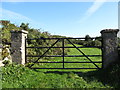
4
Loughaveely ASSI
This area west of the road is part of 4.74 ha fen and contains a number of flooded former peat workings. The Lochaveely Road cuts through the fen.
http://www.doeni.gov.uk/niea/protected_areas_home/new_assi_landing_page/county_armagh-2/loughaveely_assi.htm
Image: © Eric Jones
Taken: 10 Sep 2014
0.14 miles
5
The eastern section of the Loughaveely ASSI
The image is also taken from the Loughaveely Road. The farm house and buildings occupy a dry site above the fen.
http://www.doeni.gov.uk/niea/protected_areas_home/new_assi_landing_page/county_armagh-2/loughaveely_assi.htm
Image: © Eric Jones
Taken: 10 Sep 2014
0.15 miles
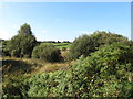
6
Wetland on the west side of Loughaveely Road
This area west of the road is part of 4.74 ha fen and contains a number of flooded former peat workings. The Lochaveely Road cuts through the fen.
http://www.doeni.gov.uk/niea/protected_areas_home/new_assi_landing_page/county_armagh-2/loughaveely_assi.htm
Image: © Eric Jones
Taken: 10 Sep 2014
0.15 miles
7
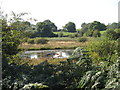
Flooded peat cuttings at Loughaveely ASSI
This area west of the road is part of 4.74 ha fen and contains a number of flooded former peat workings. The Lochaveely Road cuts through the fen.
http://www.doeni.gov.uk/niea/protected_areas_home/new_assi_landing_page/county_armagh-2/loughaveely_assi.htm
Image: © Eric Jones
Taken: 10 Sep 2014
0.15 miles
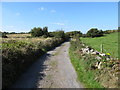
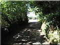
8
View north-westwards along Loughaveely Road
Image: © Eric Jones
Taken: 10 Sep 2014
0.16 miles
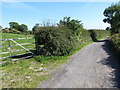
9
Another right angle bend on Loughaveely Road
This minor road has a number of right-angled and almost right-angled bends.
Image: © Eric Jones
Taken: 10 Sep 2014
0.18 miles
10
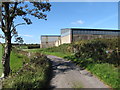
Farm sheds on Loughaveely Road
These are sited on drumlin above the Loughaveely Bog.
Image: © Eric Jones
Taken: 10 Sep 2014
0.19 miles