IMAGES TAKEN NEAR TO
St. Bridgets Park, NEWRY, BT35 9AW
Introduction
This page details the photographs taken nearby to St. Bridgets Park, BT35 9AW by members of the Geograph project.
The Geograph project started in 2005 with the aim of publishing, organising and preserving representative images for every square kilometre of Great Britain, Ireland and the Isle of Man.

There are currently over 7.5m images from over14,400 individuals and you can help contribute to the project by visiting https://www.geograph.org.uk
Image Map
Images are licensed for reuse under creativecommons.org/licenses/by-sa/2.0
Notes
- Clicking on the map will re-center to the selected point.
- The higher the marker number, the further away the image location is from the centre of the postcode.
Image Listing (33 Images Found)
Images are licensed for reuse under creativecommons.org/licenses/by-sa/2.0
Image
Details
Distance
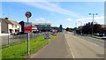
1
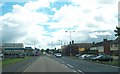
Concession Road (A37) at the crossroads in the centre of the border village of Cullaville
Image: © Eric Jones
Taken: 28 Jul 2012
0.01 miles
2
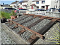
A length of 5' 3" gauge railway line providing a remainder of the GNR which linked Cullaville with the outside world
The GNR line linked Bundoran in Donegal with Dundalk in Louth. The village was connected to the rail network when the Dundalk and Enniskillen Railway opened the station on 1 April 1851. In 1927 the line was taken over by the Great Northern Railway. It was closed on 14 October 1957. Partition meant that Culloville Station was located in the Irish Republic.
Image: © Eric Jones
Taken: 18 Sep 2019
0.02 miles
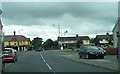
4
Culloville Cross Roads from Culloville Road
The camera point SSW. The road running left to right in the middle ground is the A37 (Concession Road). The B30 continues beyond the cross roads for some 400m before crossing into the Irish Republic at Kingham's Bridge and becoming the R179.
Image: © Eric Jones
Taken: 18 Sep 2019
0.03 miles
5
The A37 (Concession Road)/B30 crossroads in the village of Cullaville
The image was taken on the A37.
Image: © Eric Jones
Taken: 18 Sep 2019
0.03 miles
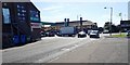
6
Cullaville Cross Roads
The image was taken from the A37.
Image: © Eric Jones
Taken: 18 Sep 2019
0.03 miles
7
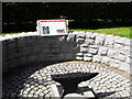
Blacksmith's Anvil, Culloville
Celebrating the old forge in the village - which was last manned by a Peter McCreesh - until the 1950s.
Image: © Dean Molyneaux
Taken: 17 Aug 2009
0.03 miles
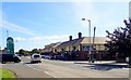
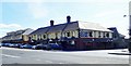
8
Culloville village
Also Cullaville. It has the distinction as the southernmost village in Northern Ireland - being right at the southern tip of County Armagh, two miles south of Crossmaglen, on the Castleblayney to Dundalk road.
Image: © Dean Molyneaux
Taken: 17 Aug 2009
0.04 miles
9
Oriental Restaurant and Off-Licence, Culloville
These are located on the SE side of Culloville Cross Roads.
Image: © Eric Jones
Taken: 18 Sep 2019
0.04 miles
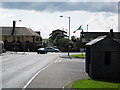
10
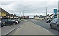
Approaching the crossroads at the centre of Cullaville
This crossroads in the middle of the village is the intersection of the A37 and B30. The B30 links Crossmaglen and the Border.
Image: © Eric Jones
Taken: 16 Apr 2011
0.05 miles