IMAGES TAKEN NEAR TO
Ballynamadda Road, NEWRY, BT35 8TF
Introduction
This page details the photographs taken nearby to Ballynamadda Road, BT35 8TF by members of the Geograph project.
The Geograph project started in 2005 with the aim of publishing, organising and preserving representative images for every square kilometre of Great Britain, Ireland and the Isle of Man.

There are currently over 7.5m images from over14,400 individuals and you can help contribute to the project by visiting https://www.geograph.org.uk
Image Map
Images are licensed for reuse under creativecommons.org/licenses/by-sa/2.0
Notes
- Clicking on the map will re-center to the selected point.
- The higher the marker number, the further away the image location is from the centre of the postcode.
Image Listing (11 Images Found)
Images are licensed for reuse under creativecommons.org/licenses/by-sa/2.0
Image
Details
Distance
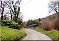
1
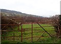
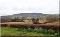
Valley floor grazing land adjoining wet woodland
This image taken from the Ballynamadda Road has the Tievecrom Mountain as its background. Tievecrom is part of the Ring of Gullion.
Image: © Eric Jones
Taken: 9 Apr 2018
0.06 miles
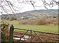
2
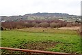
Drumlins and wet woodland on the valley floor south of Dromintee
Slieve Gullion forms the background.
Image: © Eric Jones
Taken: 9 Apr 2018
0.09 miles
3
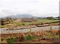
Building site on the Ballynamadda Road
This house will command a fine view northwards along the valley towards Slieve Gullion in the background.
Image: © Eric Jones
Taken: 9 Apr 2018
0.10 miles
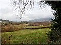
4
Wooded wetland south of Dromintee
The wetland is located on the floor of a glaciated valley. The mountain behind is Tievecrom - a part of the Ring of Gullion.
Image: © Eric Jones
Taken: 9 Apr 2018
0.15 miles
5
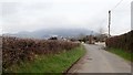
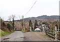
View North along Ballynamadda Road
Slieve Gullion forms the background.
Image: © Eric Jones
Taken: 9 Apr 2018
0.16 miles
6
Wet woodland between the Ballynamadda Road and the Tievecrom Road
Tivevecrom, a part of the Ring of Gullion, forms the background.
Image: © Eric Jones
Taken: 9 Apr 2018
0.18 miles
7
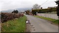
View NNW along Ballynamadda Road
The mountain in the background is Slieve Gullion.
Image: © Eric Jones
Taken: 9 Apr 2018
0.20 miles
8
Bend in the upper section of the Ballynamadda Road
The forested Tievecrom - part of the Ring of Gullion - forms a dramatic background.
Image: © Eric Jones
Taken: 9 Apr 2018
0.20 miles
9
View West across valley floor wetlands towards Tievecrom
Tievecrom is part of the Ring of Gullion Hills. The western slope of the hill overlooks the village of Forkill/Forkhill.
Image: © Eric Jones
Taken: 9 Apr 2018
0.22 miles