IMAGES TAKEN NEAR TO
Bernish Road, NEWRY, BT35 8PZ
Introduction
This page details the photographs taken nearby to Bernish Road, BT35 8PZ by members of the Geograph project.
The Geograph project started in 2005 with the aim of publishing, organising and preserving representative images for every square kilometre of Great Britain, Ireland and the Isle of Man.

There are currently over 7.5m images from over14,400 individuals and you can help contribute to the project by visiting https://www.geograph.org.uk
Image Map
Images are licensed for reuse under creativecommons.org/licenses/by-sa/2.0
Notes
- Clicking on the map will re-center to the selected point.
- The higher the marker number, the further away the image location is from the centre of the postcode.
Image Listing (14 Images Found)
Images are licensed for reuse under creativecommons.org/licenses/by-sa/2.0
Image
Details
Distance
1
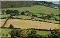
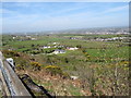
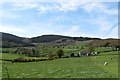
Hillside fields, Altnaveigh, Newry
A patchwork of fields (typical scenery in the area) seen from the Bernish viewpoint Image at a height of about 700ft.
Image: © Albert Bridge
Taken: 29 Sep 2012
0.07 miles
2
T- junction on the Bernish Road
Both roads are known as Bernish Road.
Image: © Eric Jones
Taken: 19 Apr 2014
0.07 miles
3
New houses below the Bernish Viewpoint
These lie between Bernish Road and the A1.
Image: © Eric Jones
Taken: 21 Mar 2019
0.09 miles
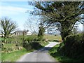
4
Bend in the Bernish Road
The hill in the background is Ballymacdermot Mountain.
Image: © Eric Jones
Taken: 19 Apr 2014
0.09 miles
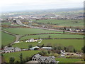
5
Houses on Bernish Road seen from the Bernish View Point
The A1 can be seen in the middle ground and beyond the city of Newry.
Image: © Eric Jones
Taken: 19 Apr 2014
0.09 miles
6
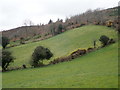
Intake land on the slopes of Ballymacdermot Mountain
The image was taken from the Bernish Road.
Image: © Eric Jones
Taken: 21 Mar 2019
0.13 miles
7
The Bernish Road, Newry
The Bernish Road is a minor and, in places, very narrow road on the western side of Newry. This view, of a bend, is from the Bernish viewpoint Image at a height of about 700ft. Part of the Newry bypass Image intrudes at top right.
Image: © Albert Bridge
Taken: 29 Sep 2012
0.14 miles
8
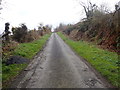
Bernish Road climbing towards the Viewpoint
Image: © Eric Jones
Taken: 21 Mar 2019
0.14 miles
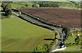
9
Farmhouse and buildings west of Bernish Road
Camlough Mountain forms the background.
Image: © Eric Jones
Taken: 19 Apr 2014
0.17 miles
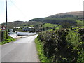
10
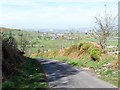
Bernish Road descending northwards
The A1 can be seen in the top right hand corner.
Image: © Eric Jones
Taken: 19 Apr 2014
0.19 miles