IMAGES TAKEN NEAR TO
Chapel Road, NEWRY, BT35 8JZ
Introduction
This page details the photographs taken nearby to Chapel Road, BT35 8JZ by members of the Geograph project.
The Geograph project started in 2005 with the aim of publishing, organising and preserving representative images for every square kilometre of Great Britain, Ireland and the Isle of Man.

There are currently over 7.5m images from over14,400 individuals and you can help contribute to the project by visiting https://www.geograph.org.uk
Image Map
Images are licensed for reuse under creativecommons.org/licenses/by-sa/2.0
Notes
- Clicking on the map will re-center to the selected point.
- The higher the marker number, the further away the image location is from the centre of the postcode.
Image Listing (8 Images Found)
Images are licensed for reuse under creativecommons.org/licenses/by-sa/2.0
Image
Details
Distance
1
The Flurry Valley from Tamnaghbane Road
The Flurry drains southwards towards Dundalk Bay.
Image: © Eric Jones
Taken: 11 Apr 2014
0.05 miles
2
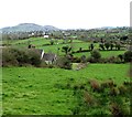
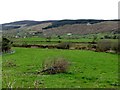
View across the Upper Flurry Valley to a clachan of houses on the Chapel Road
Image: © Eric Jones
Taken: 11 Apr 2014
0.07 miles
3
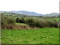
View north westwards up the Upper Flurry Valley towards the Camlough Gap
Image: © Eric Jones
Taken: 11 Apr 2014
0.11 miles
4
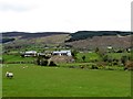
The upper reaches of the Flurry Valley
This image taken in a southerly direction shows the upper reaches of the Flurry Valley. In the background beyond the village of Meigh are the northern flank of the Cooley Mountains and on the right Faughill Mountain, the site of a large British Army fortress and observation base commanding the road and rail corridor to and from the South.
Image
Image: © Eric Jones
Taken: 11 Apr 2014
0.12 miles
5
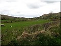
View west across the upper Flurry valley
In the background are the forested slopes of Slieve Gullion.
Image: © Eric Jones
Taken: 11 Apr 2014
0.16 miles
6
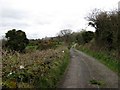
View north along Mill Lane
This is part of the Ring of Gullion Way.
http://www.walkni.com/walks/46/ring-of-gullion-way/
Image: © Eric Jones
Taken: 11 Apr 2014
0.22 miles
7
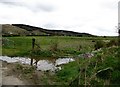
A possible building site on Mill Road
The aerials in the background are on Camlough Mountain.
Image: © Eric Jones
Taken: 11 Apr 2014
0.22 miles
8
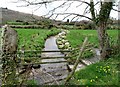
Headwater of the Flurry river from the Mill Road
This was used to power the watermill which stood on the other side of the road.
Image: © Eric Jones
Taken: 11 Apr 2014
0.23 miles