IMAGES TAKEN NEAR TO
Sloans Road, NEWRY, BT35 8GP
Introduction
This page details the photographs taken nearby to Sloans Road, BT35 8GP by members of the Geograph project.
The Geograph project started in 2005 with the aim of publishing, organising and preserving representative images for every square kilometre of Great Britain, Ireland and the Isle of Man.

There are currently over 7.5m images from over14,400 individuals and you can help contribute to the project by visiting https://www.geograph.org.uk
Image Map
Images are licensed for reuse under creativecommons.org/licenses/by-sa/2.0
Notes
- Clicking on the map will re-center to the selected point.
- The higher the marker number, the further away the image location is from the centre of the postcode.
Image Listing (13 Images Found)
Images are licensed for reuse under creativecommons.org/licenses/by-sa/2.0
Image
Details
Distance
1
Cairn in a field east of Cottage Road, Clontygora
This is believed to contain the remains of a small court tomb.
http://apps.ehsni.gov.uk/ambit/docs/ARM/ARM_029/ARM_029_012/Public/SM7-ARM-029-012-01.pdf
Image]
Image: © Eric Jones
Taken: 26 Feb 2015
0.14 miles
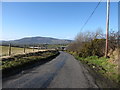
2
The southern end of Cottage Road, Killeen
Image: © Eric Jones
Taken: 26 Feb 2015
0.16 miles
3
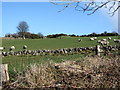
Sheep grazings on the east side of Cottage Road
The Clontygora Small Cairn can be seen in the middle of the field.
http://apps.ehsni.gov.uk/ambit/docs/ARM/ARM_029/ARM_029_012/Public/SM7-ARM-029-012-01.pdf
Image]
Image: © Eric Jones
Taken: 26 Feb 2015
0.16 miles
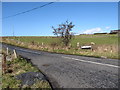
4
The Cottage Road junction on the Ferryhill Road
This junction is situated near the Clontygora Court Tomb.
Image: © Eric Jones
Taken: 26 Feb 2015
0.16 miles
5
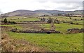
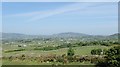
Drumlins pushed against the Ring of Gullion
In common with many other drumlin areas in the north of Ireland the landscape is characterised by a strong geometric pattern of medium sized fields devoted to pasture. The hills of the eastern and southern section of the Ring of Gullion forms the background.
Image: © Eric Jones
Taken: 13 Mar 2018
0.16 miles
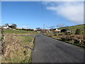
6
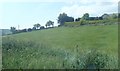
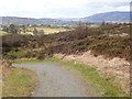
Hill slope meadow at the junction of Ferryhill Road and Cottage Road
Image: © Eric Jones
Taken: 7 Jun 2018
0.18 miles
7
Descending westwards along Cottage Road, Killeen
Slieve Gullion provides the background.
Image: © Eric Jones
Taken: 26 Feb 2015
0.18 miles
8
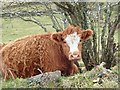
Store cattle off the Ferryhill Road
The farming economy of South Armagh is based on sheep and store cattle rearing.
Image: © Eric Jones
Taken: 13 Mar 2018
0.18 miles
9
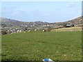
The village of Killeen from the Upper Ferryhill Road
The dispersed village of Killeen is located on the eastern half of the Plain of Meigh. Hills of the Ring of Gullion form the background.
Image: © Eric Jones
Taken: 7 Jun 2018
0.20 miles
10
Western boundary wall of the Flagstaff View Point site
This WSW view shows a large section of the Gullion caldera. Slieve Gullion. the largest of the upland blocks in the background of the image is the remains of the original volcano. Parts of the south-eastern section of the Gullion Ring Dyke occupies much of the background on the left and, seen between the Cooley Mountains and Slieve Gullion, are the south-western hills of the Ring Dyke, including Croslieve and Tievecrom in the Forkill area.
Image: © Eric Jones
Taken: 13 Mar 2018
0.21 miles