IMAGES TAKEN NEAR TO
Lisnabrague Orlits, NEWRY, BT35 6RA
Introduction
This page details the photographs taken nearby to Lisnabrague Orlits, BT35 6RA by members of the Geograph project.
The Geograph project started in 2005 with the aim of publishing, organising and preserving representative images for every square kilometre of Great Britain, Ireland and the Isle of Man.

There are currently over 7.5m images from over14,400 individuals and you can help contribute to the project by visiting https://www.geograph.org.uk
Image Map
Images are licensed for reuse under creativecommons.org/licenses/by-sa/2.0
Notes
- Clicking on the map will re-center to the selected point.
- The higher the marker number, the further away the image location is from the centre of the postcode.
Image Listing (6 Images Found)
Images are licensed for reuse under creativecommons.org/licenses/by-sa/2.0
Image
Details
Distance
1
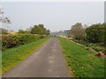
View North along the Newry Canal towpath between Poyntzpass and Scarva
Image: © Eric Jones
Taken: 18 Apr 2019
0.09 miles
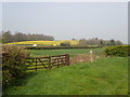
2
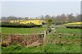
Sheugh emerging from under the railway line and draining in the direction of the Newry Canal
The reclaimed marshes on the valley floor yield a good crop of grass, while the drier soils of the drumlins support oilseed rape. The image was taken from the Newry Canal Towpath.
Image: © Eric Jones
Taken: 18 Apr 2019
0.13 miles
3
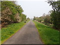
The Newry Canal Towpath North of Poyntzpass
The depleted canal can be seen on the right.
Image: © Eric Jones
Taken: 18 Apr 2019
0.19 miles
4
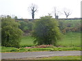
Bann Road above the glacial valley used by the canal
The polled trees are along the edge of the Bann Road.
Image: © Eric Jones
Taken: 18 Apr 2019
0.21 miles
5
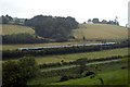
Unidentified Train
A unidentified train waits at the signal on the Belfast/Dublin mainline before proceeding to Tandragee. Poyntz Pass to the left, Tandragee to the right, in the foreground is the Newry Canal and Towpath, mid picture, Belfast to Dublin mainline, befond the train is the Auglish Rd.
Image: © Wilson Adams
Taken: 13 Jul 2007
0.23 miles
6
Traffic travelling South along the Tandragee Road
This image was taken from the Newry Canal Towpath.
Image: © Eric Jones
Taken: 18 Apr 2019
0.23 miles