IMAGES TAKEN NEAR TO
Tullymore Road, NEWRY, BT35 6QP
Introduction
This page details the photographs taken nearby to Tullymore Road, BT35 6QP by members of the Geograph project.
The Geograph project started in 2005 with the aim of publishing, organising and preserving representative images for every square kilometre of Great Britain, Ireland and the Isle of Man.

There are currently over 7.5m images from over14,400 individuals and you can help contribute to the project by visiting https://www.geograph.org.uk
Image Map
Images are licensed for reuse under creativecommons.org/licenses/by-sa/2.0
Notes
- Clicking on the map will re-center to the selected point.
- The higher the marker number, the further away the image location is from the centre of the postcode.
Image Listing (2 Images Found)
Images are licensed for reuse under creativecommons.org/licenses/by-sa/2.0
Image
Details
Distance
1
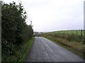
Tullymore Road, Loughbrickland
Townland of Tullymore.
Image: © Dean Molyneaux
Taken: 18 Oct 2009
0.08 miles
2
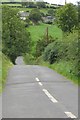
Drumlin country
A typical Co Down switchback road . These minor roads tend to go over, rather than round, the hills. This one is the Tullymore Road between Poyntzpass and Loughbrickland.
Image: © Robert Ashby
Taken: 2 Sep 2015
0.13 miles