IMAGES TAKEN NEAR TO
Emmet Place, NEWRY, BT35 6JL
Introduction
This page details the photographs taken nearby to Emmet Place, BT35 6JL by members of the Geograph project.
The Geograph project started in 2005 with the aim of publishing, organising and preserving representative images for every square kilometre of Great Britain, Ireland and the Isle of Man.

There are currently over 7.5m images from over14,400 individuals and you can help contribute to the project by visiting https://www.geograph.org.uk
Image Map
Images are licensed for reuse under creativecommons.org/licenses/by-sa/2.0
Notes
- Clicking on the map will re-center to the selected point.
- The higher the marker number, the further away the image location is from the centre of the postcode.
Image Listing (64 Images Found)
Images are licensed for reuse under creativecommons.org/licenses/by-sa/2.0
Image
Details
Distance
1
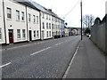
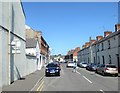
The junction with Barrack Street on the Armagh Road
Barrack Street, as the name suggests was the site of the British Army barracks in Newry, Housed in the disused White Linen Hall from the 1839s onwards it accommodated garrisons of 600 and more soldiers. With the rapidly deteriorating security situation in the 1970s and the need for widespread use of helicopters the garrison was relocated to another former linen mill, that at the nearby village of Bessbrook. Housing Executive social housing now occupy the site of the former barracks at Newry.
http://www.newryjournal.co.uk/2005/01/10/newry-military-barracks/
Image: © Eric Jones
Taken: 9 May 2016
0.06 miles
2
The junction of Barrack Street and Canal Street, Newry
The houses are build on the site of the old army barracks at Newry.
http://www.newryjournal.co.uk/2005/01/10/newry-military-barracks/
Image: © Eric Jones
Taken: 9 May 2016
0.07 miles
3
The entrance into Barrack Street
The houses are build on the site of the old army barracks at Newry.
http://www.newryjournal.co.uk/2005/01/10/newry-military-barracks/
Image: © Eric Jones
Taken: 9 May 2016
0.07 miles
4
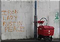
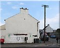
Dissident Republican graffiti on the corner of Barrack Street
Image: © Eric Jones
Taken: 9 May 2016
0.07 miles
5
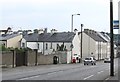
Modern terraced housing in Canal Street
These are built on the former site of the Newry Army Barracks. They face on to the A27.
Image: © Eric Jones
Taken: 9 May 2016
0.08 miles
6
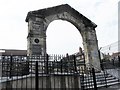
Archway of the former Linen Hall
Built in 1783 the Linen Hall was in the early 19thC converted into a large and permanent military barracks which survived until the 1923 when the Army moved to the nearby village of Bessbrook. In its glory days Newry Barracks had a complement of 600 men. After the withdrawal of the military the barracks became an inner city working class housing estate. In recent decades these run down dwellings have been replaced by modern houses.
http://www.newryjournal.co.uk/2005/01/10/newry-military-barracks/
http://www.newrymemoirs.com/stories_pages/oldbarracks_1.html
Image: © Eric Jones
Taken: 9 May 2016
0.10 miles
8
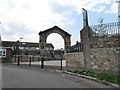
The historic archway of the former Linenhall Square Barracks
Built in 1783 the Linen Hall was in the early 19thC converted into a large and permanent military barracks which survived until 1923 when the Army moved to the nearby village of Bessbrook. In its glory days Newry Barracks had a complement of 600 men. After the withdrawal of the military the barracks became an inner city working class housing estate. In recent decades these run down dwellings have been replaced by modern houses.
http://www.newryjournal.co.uk/2005/01/10/newry-military-barracks/
http://www.newrymemoirs.com/stories_pages/oldbarracks_1.html
Image: © Eric Jones
Taken: 9 May 2016
0.11 miles
9
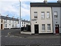
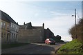
Erskine Street, Newry
This is a side street off the A27.
Image: © Eric Jones
Taken: 3 Jun 2016
0.12 miles
10
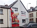
'Hands off Daisy Hill Hospital' mural at the junction of Catherine Street and Canal Street, Newry
Image: © Eric Jones
Taken: 21 Mar 2019
0.13 miles