
IMAGES TAKEN NEAR TO
Church Hill, NEWRY, BT35 6FJ
Introduction
This page details the photographs taken nearby to Church Hill, BT35 6FJ by members of the Geograph project.
The Geograph project started in 2005 with the aim of publishing, organising and preserving representative images for every square kilometre of Great Britain, Ireland and the Isle of Man.

There are currently over 7.5m images from over14,400 individuals and you can help contribute to the project by visiting https://www.geograph.org.uk
Image Map
Images are licensed for reuse under creativecommons.org/licenses/by-sa/2.0
Notes
- Clicking on the map will re-center to the selected point.
- The higher the marker number, the further away the image location is from the centre of the postcode.
Image Listing (2 Images Found)
Images are licensed for reuse under creativecommons.org/licenses/by-sa/2.0
Image
Details
Distance
1
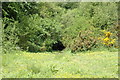
Overgrown entrance to Lissummon Railway tunnel
The longer of two tunnels on the old Newry to Armagh railway line.
The line continued in operation until 1933 when, following a strike, the passenger service between Goraghwood and Armagh was withdrawn, and the Armagh - Markethill section closed completely. Goods traffic continued on the Markethill to Goraghwood section until 1957, and in 1965 the line closed completely.
Some facts and numbers about Lissummon Tunnel:
At 1759 yards (1608 metres) long - 1 yard short of a mile - it is the longest railway tunnel in Ireland.
It is perfectly straight and runs approximately in a SE-NW direction. From one end you can see the light at the other.
It is lined throughout with stone and brick and along the north wall are safety alcoves at 20 yard intervals.
The track rises throughout the tunnel at a gradient of 1:75 (a climb of approximately 70 feet over the length of the tunnel).
Image: © Graeme McCusker
Taken: 30 May 2010
0.24 miles
2
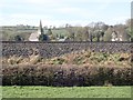
St Mary's CoI Drumbanagher viewed from the towpath
St Mary's was built by the Closes, the squires of Drumbanagher House, in the late 1840s. The ruins of an older church stands in the adjoining graveyard. Here, the church is seen from the Newry Canal towpath and across the embankment of the Belfast to Dublin railway line.
http://www.strongholdpreservation.com/st-mary%27s-church-of-ireland,-drumbanagher-bird-control-proofing-deter-pigeon-spikes-northern-ireland-ni.aspx
Image: © Eric Jones
Taken: 21 Feb 2019
0.24 miles