IMAGES TAKEN NEAR TO
Corliss Road, NEWRY, BT35 0LL
Introduction
This page details the photographs taken nearby to Corliss Road, BT35 0LL by members of the Geograph project.
The Geograph project started in 2005 with the aim of publishing, organising and preserving representative images for every square kilometre of Great Britain, Ireland and the Isle of Man.

There are currently over 7.5m images from over14,400 individuals and you can help contribute to the project by visiting https://www.geograph.org.uk
Image Map
Images are licensed for reuse under creativecommons.org/licenses/by-sa/2.0
Notes
- Clicking on the map will re-center to the selected point.
- The higher the marker number, the further away the image location is from the centre of the postcode.
Image Listing (7 Images Found)
Images are licensed for reuse under creativecommons.org/licenses/by-sa/2.0
Image
Details
Distance
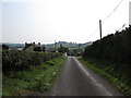
1
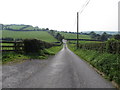
View south-westwards along Corliss Road from near the junction with Drumlougher Road
Image: © Eric Jones
Taken: 11 Sep 2014
0.13 miles
2
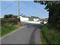
Corliss Road at its junction with Drumlougher Road
Drumlougher Road comes in from the right. At the junction Corliss Road continues left to reach the border with the Irish Republic.
Image: © Eric Jones
Taken: 11 Sep 2014
0.15 miles
3
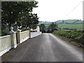
Corliss Road approaching the junction with Drumlougher Road
This image is taken from the direction of the Border.
Image: © Eric Jones
Taken: 11 Sep 2014
0.16 miles
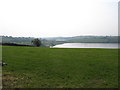
4
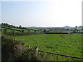
View SE from Drumlougher Road across drumlin slopes land towards an inter-drumlin wetland
The lake in the wetland area is Drumlougher Lough.
Image: © Eric Jones
Taken: 11 Sep 2014
0.18 miles
5
View south along Corliss Road near its junction with Drumlougher Road
Image: © Eric Jones
Taken: 11 Sep 2014
0.18 miles
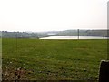
6
The north-eastern shores of Lough Patrick
The lake in the background is Lough Alina.
Image: © Eric Jones
Taken: 11 Sep 2014
0.22 miles
7
Loughs Patrick and Alina from Corliss Road
Image: © Eric Jones
Taken: 11 Sep 2014
0.25 miles