IMAGES TAKEN NEAR TO
Bog Road, NEWRY, BT35 0JY
Introduction
This page details the photographs taken nearby to Bog Road, BT35 0JY by members of the Geograph project.
The Geograph project started in 2005 with the aim of publishing, organising and preserving representative images for every square kilometre of Great Britain, Ireland and the Isle of Man.

There are currently over 7.5m images from over14,400 individuals and you can help contribute to the project by visiting https://www.geograph.org.uk
Image Map
Images are licensed for reuse under creativecommons.org/licenses/by-sa/2.0
Notes
- Clicking on the map will re-center to the selected point.
- The higher the marker number, the further away the image location is from the centre of the postcode.
Image Listing (6 Images Found)
Images are licensed for reuse under creativecommons.org/licenses/by-sa/2.0
Image
Details
Distance
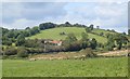
1
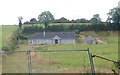
Bungalow below the Lisleitrim Fort
A multi-vallate fort, Lisleitrim dates from the Early Christian Period.
https://apps.communities-ni.gov.uk/NISMR-PUBLIC/docs/ARM/ARM_027/ARM_027_003/Public/SM7-ARM-027-003.pdf
Image: © Eric Jones
Taken: 28 Aug 2019
0.11 miles
2
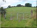
Lisleitrim Hill Fort from the Lisleitrim Road
A multi-vallate fort, Lisleitrim dates from the Early Christian Period.
https://apps.communities-ni.gov.uk/NISMR-PUBLIC/docs/ARM/ARM_027/ARM_027_003/Public/SM7-ARM-027-003.pdf
Image: © Eric Jones
Taken: 28 Aug 2019
0.21 miles
3
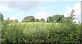
Lisleitrim Iron Age Fort from the Lisleitrim Road
A multi-vallate fort, Lisleitrim dates from the Early Christian Period (c.400-800)
https://apps.communities-ni.gov.uk/NISMR-PUBLIC/docs/ARM/ARM_027/ARM_027_003/Public/SM7-ARM-027-003.pdf
Image: © Eric Jones
Taken: 28 Aug 2019
0.21 miles
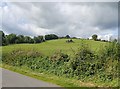
4
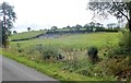
The Lisleitrim Hill Fort from the Bog Road
https://apps.communities-ni.gov.uk/NISMR-PUBLIC/docs/ARM/ARM_027/ARM_027_003/Public/SM7-ARM-027-003.pdf
Image: © Eric Jones
Taken: 28 Aug 2019
0.21 miles
5
Lisleitrim Hill Fort
This image was taken from the Sheetrim Road. This is a spectacular multivallate hill fort, one of the best in the north of Ireland.
https://apps.communities-ni.gov.uk/NISMR-PUBLIC/docs/ARM/ARM_027/ARM_027_003/Public/SM7-ARM-027-003.pdf
Image: © Eric Jones
Taken: 28 Aug 2019
0.21 miles
6
Lisleitrim Fort from the Lisleitrim Road
The fort caps the hill top. The ruins in the centre of the slope dates back only to the 19thC. A multi-vallate fort, Lisleitrim dates from the Early Christian Period.
https://apps.communities-ni.gov.uk/NISMR-PUBLIC/docs/ARM/ARM_027/ARM_027_003/Public/SM7-ARM-027-003.pdf
Image: © Eric Jones
Taken: 28 Aug 2019
0.22 miles