IMAGES TAKEN NEAR TO
Cortamlat Road, NEWRY, BT35 0DX
Introduction
This page details the photographs taken nearby to Cortamlat Road, BT35 0DX by members of the Geograph project.
The Geograph project started in 2005 with the aim of publishing, organising and preserving representative images for every square kilometre of Great Britain, Ireland and the Isle of Man.

There are currently over 7.5m images from over14,400 individuals and you can help contribute to the project by visiting https://www.geograph.org.uk
Image Map
Images are licensed for reuse under creativecommons.org/licenses/by-sa/2.0
Notes
- Clicking on the map will re-center to the selected point.
- The higher the marker number, the further away the image location is from the centre of the postcode.
Image Listing (7 Images Found)
Images are licensed for reuse under creativecommons.org/licenses/by-sa/2.0
Image
Details
Distance
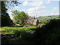
1
Abandoned farmhouse on the Glen Road
The amalgamation of farming units and the exodus of many Protestant families from the Border areas during the Troubles have led to the abandonment and dereliction of many farmhouses in this area.
Image: © Eric Jones
Taken: 7 Jun 2019
0.20 miles
2
Farmhouse on the Glen Road
The hill in the background right is in the Republic's Co Monaghan.
Image: © Eric Jones
Taken: 7 Jun 2019
0.23 miles
4
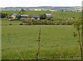
Farm sheds at Clarkesbridge
This farm is located past Clarkesbridge Presbyterian Church on the Cortamlat Road. Mullyash Mountain in Co Monaghan forms the background.
Image: © Eric Jones
Taken: 7 Jun 2019
0.25 miles
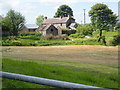
5
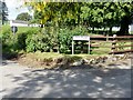
Traditional homestead at the eastern entrance to Glen Road, Cortamlet
Image: © Eric Jones
Taken: 7 Jun 2019
0.25 miles
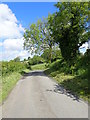
6
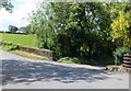
The Glen Road junction on the Cortamlat Road at Clarkesbridge
Image: © Eric Jones
Taken: 7 Jun 2019
0.25 miles
7
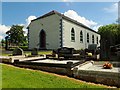
Clerkesbridge Presbyterian Church, Cortamlat TD
This congregation was first formed in 1791. A schism in the 1840s led to the formation of a rival congregation Tullyvallan Reformed Presbyterian Church on the Tullyneill Road. In 1887 Clerkesbridge formed a union with the First Newtownhamilton church and briefly in the 1930s with Garmany's Grove and McKelvey's Grove. First Newtownhamilton closed in the 1980s and 1999 Garmany's Grove and McKelvey's Grove rejoined the union. The union are part of the Newry Presbytery.
Image: © Eric Jones
Taken: 7 Jun 2019
0.25 miles