IMAGES TAKEN NEAR TO
Ballycoshone Road, NEWRY, BT34 5XE
Introduction
This page details the photographs taken nearby to Ballycoshone Road, BT34 5XE by members of the Geograph project.
The Geograph project started in 2005 with the aim of publishing, organising and preserving representative images for every square kilometre of Great Britain, Ireland and the Isle of Man.

There are currently over 7.5m images from over14,400 individuals and you can help contribute to the project by visiting https://www.geograph.org.uk
Image Map
Images are licensed for reuse under creativecommons.org/licenses/by-sa/2.0
Notes
- Clicking on the map will re-center to the selected point.
- The higher the marker number, the further away the image location is from the centre of the postcode.
Image Listing (25 Images Found)
Images are licensed for reuse under creativecommons.org/licenses/by-sa/2.0
Image
Details
Distance
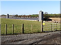
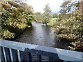
2

Ballycoshone Flax Mill on the River Bann
This disused mill is located at the junction of Cavan Road and Ballycoshone Road.
Image: © Eric Jones
Taken: 9 Oct 2018
0.08 miles
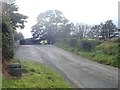
3
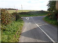
The Cavan Road/Ballycoshone Road junction
The image was taken from the bridge across the Upper Bann.
Image: © Eric Jones
Taken: 9 Oct 2018
0.09 miles
4

A bend in the Upper Bann south of the Cavan Road bridge
Image: © Eric Jones
Taken: 5 Nov 2011
0.09 miles
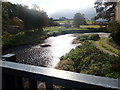
5
View East across the Cavan Road Bridge over the Upper Bann
The buildings on the opposite bank are those of the derelict Ballycoshone Flax Mill.
Image: © Eric Jones
Taken: 9 Oct 2018
0.09 miles
6
The Upper Bann above the Cavan Road Bridge
A chicken rearing unit can be seen in the background.
Image: © Eric Jones
Taken: 9 Oct 2018
0.09 miles
7
The Upper Bann below the Cavan Road Bridge
Image: © Eric Jones
Taken: 9 Oct 2018
0.11 miles
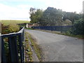
8
Marker stone on the Townland Border between Drumnascamph TD and Ballycoshone Upper TD
At the right angle bend in the background the Cavan Road swings left to cross the Upper Bann at the Ballycoshone Bridge (also known as the Cavan Road Bridge).
Image: © Eric Jones
Taken: 9 Oct 2018
0.11 miles
9
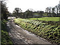
The Cavan Road at its approach to the bridge over the Bann
Here the river runs parallel with the River Bann and is liable to flooding after heavy rains.
Image: © Eric Jones
Taken: 5 Nov 2011
0.13 miles
10

View north along the Upper Bann from the Cavan Road Bridge
Image: © Eric Jones
Taken: 5 Nov 2011
0.15 miles