IMAGES TAKEN NEAR TO
Mill Road, NEWRY, BT34 5UZ
Introduction
This page details the photographs taken nearby to Mill Road, BT34 5UZ by members of the Geograph project.
The Geograph project started in 2005 with the aim of publishing, organising and preserving representative images for every square kilometre of Great Britain, Ireland and the Isle of Man.

There are currently over 7.5m images from over14,400 individuals and you can help contribute to the project by visiting https://www.geograph.org.uk
Image Map
Images are licensed for reuse under creativecommons.org/licenses/by-sa/2.0
Notes
- Clicking on the map will re-center to the selected point.
- The higher the marker number, the further away the image location is from the centre of the postcode.
Image Listing (3 Images Found)
Images are licensed for reuse under creativecommons.org/licenses/by-sa/2.0
Image
Details
Distance
1
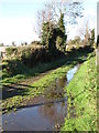
Field access lane off Mill Road
The remnants of flooding earlier in the week remain.
Image: © Eric Jones
Taken: 5 Nov 2011
0.11 miles
2
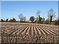
Potato field north of Mill Road
The potato harvest of 2011 in Ireland was good.
Image: © Eric Jones
Taken: 5 Nov 2011
0.11 miles
3
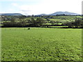
The floodplain of the Upper Bann from Mill Road
The Bann rises in the Mountains of Mourne (seen in the background) and flows northwards for 80 miles to join the North Atlantic at Portstewart near Coleraine.
Image: © Eric Jones
Taken: 5 Nov 2011
0.15 miles