IMAGES TAKEN NEAR TO
Castle Street, NEWRY, BT34 5QR
Introduction
This page details the photographs taken nearby to Castle Street, BT34 5QR by members of the Geograph project.
The Geograph project started in 2005 with the aim of publishing, organising and preserving representative images for every square kilometre of Great Britain, Ireland and the Isle of Man.

There are currently over 7.5m images from over14,400 individuals and you can help contribute to the project by visiting https://www.geograph.org.uk
Image Map
Images are licensed for reuse under creativecommons.org/licenses/by-sa/2.0
Notes
- Clicking on the map will re-center to the selected point.
- The higher the marker number, the further away the image location is from the centre of the postcode.
Image Listing (196 Images Found)
Images are licensed for reuse under creativecommons.org/licenses/by-sa/2.0
Image
Details
Distance
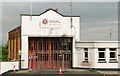
1
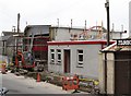
The rebuilding of Rathfriland Fire and Rescue Station
Image: © Eric Jones
Taken: 13 Mar 2012
0.02 miles
2
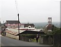
Rathfriland's new Fire and Rescue Station from Castle Hill
The station is manned by retained firemen.
Image: © Eric Jones
Taken: 13 Mar 2012
0.02 miles
3
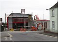
Rathfriland's new Fire and Rescue Station
This state of the art station is being built on the site of the old station which was badly damaged by fire in 2009
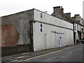
Image
Since 2009 the NIFRS had been housed in an old garage in Castle Street.
Image: © Eric Jones
Taken: 13 Mar 2012
0.02 miles
5
The site of the birthplace of Mrs Catherine Schubert nee O'Hare
Catherine's claim to fame was that she was the first white woman to cross the Rockies and the mother of the first white baby born in British Colombia. The site, in Castle Street, is now occupied by a garage.
http://www.bcarchives.gov.bc.ca/exhibits/timemach/galler10/frames/schubert.htm
Image: © Eric Jones
Taken: 20 Oct 2011
0.02 miles
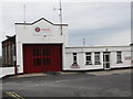
6
Rathfriland fire station
Damaged by fire on overnight on 30/31 July 2009. The media made much of the absence of a smoke alarm. Alarms don’t prevent fires; they only alert the residents (none in this case).
Image: © Albert Bridge
Taken: 11 Aug 2009
0.02 miles
7
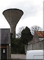
The Rathfriland Water Tower from the Ballyroney Road
Image: © Eric Jones
Taken: 24 Mar 2012
0.03 miles
8
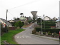
The ascent to the summit of Castle Hill
Castle Hill, once the site of a castle, is dominated by the Rathfriland Water Tower. The tower is visible for miles around.
Image: © Eric Jones
Taken: 13 Mar 2012
0.03 miles
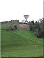
10
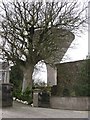
The remains of Rathfriland Castle and the town's better known water tower
The castle was built by the Magennises the Lords of Iveagh. Following the rebellion of 1641, when the Magennises backed the Irish Catholic cause, most of the castle was pulled down by the Planter William Hawkins of London. The rest was destroyed by the Puritan Roundhead General Henry Ireton. A tiny remnant of a wall is incorporated in the flat topped build on the right of the photo. The water tower dates from the late 1970s. The red, white and blue pattern on the upper rim is the work of intrepid Loyalists.
Image: © Eric Jones
Taken: 13 Mar 2012
0.04 miles