IMAGES TAKEN NEAR TO
Stewarts Crescent, NEWRY, BT34 5QL
Introduction
This page details the photographs taken nearby to Stewarts Crescent, BT34 5QL by members of the Geograph project.
The Geograph project started in 2005 with the aim of publishing, organising and preserving representative images for every square kilometre of Great Britain, Ireland and the Isle of Man.

There are currently over 7.5m images from over14,400 individuals and you can help contribute to the project by visiting https://www.geograph.org.uk
Image Map
Images are licensed for reuse under creativecommons.org/licenses/by-sa/2.0
Notes
- Clicking on the map will re-center to the selected point.
- The higher the marker number, the further away the image location is from the centre of the postcode.
Image Listing (92 Images Found)
Images are licensed for reuse under creativecommons.org/licenses/by-sa/2.0
Image
Details
Distance
1
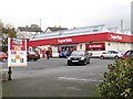
SuperValu Supermarket, John Street, Rathfriland
Image: © Eric Jones
Taken: 27 Oct 2011
0.05 miles
2
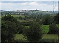
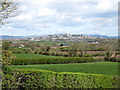
The town of Rathfriland viewed from the Goward Road
It is the proud boast of Rathfriland folk that "a town set on a hill cannot be hid".
Image: © Eric Jones
Taken: 15 May 2014
0.06 miles
3
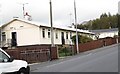
Prefabricated housing in Glentariff Park
Image: © Eric Jones
Taken: 27 Oct 2011
0.07 miles
4
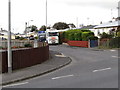
Prefabricated houses facing on to John Street
Image: © Eric Jones
Taken: 27 Oct 2011
0.07 miles
5
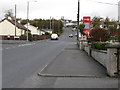
John Street, Rathfriland
This leads upwards towards the centre of the town.
Image: © Eric Jones
Taken: 27 Oct 2011
0.09 miles
6
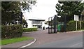
Rathfriland's Community and Leisure Centre, John Street
Image: © Eric Jones
Taken: 27 Oct 2011
0.10 miles
7

A town on a hill - Rathfriland from the Ballygorian Road
Rathfriland, and especially its water tower, is visible for miles around. This view is taken from high ground north-west of Hilltown.
Image: © Eric Jones
Taken: 14 Apr 2012
0.11 miles
8
The town of Rathfriland from the New Line, Tullyquilly
"A city on a hill cannot be hidden".
Image: © Eric Jones
Taken: 27 Oct 2011
0.13 miles
9
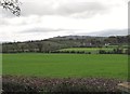
View north-eastwards across farrmland towards Rathfriland
The land between the view point and the outskirts of Rathfriland is in the Newry and Mourne Local Government District. The built up area of Rathfriland was transferred to the Banbridge Local Government District in 1993.
Image: © Eric Jones
Taken: 14 Apr 2012
0.13 miles
10
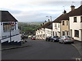
View down John Street from Church Square
At first sight, the view is somewhat reminiscent of that of Gold Hill, the location for the immortal brass-band accompanied Hovis ad of years ago.
Image
Image: © Eric Jones
Taken: 27 Oct 2011
0.14 miles