IMAGES TAKEN NEAR TO
Back Road, NEWRY, BT34 5QF
Introduction
This page details the photographs taken nearby to Back Road, BT34 5QF by members of the Geograph project.
The Geograph project started in 2005 with the aim of publishing, organising and preserving representative images for every square kilometre of Great Britain, Ireland and the Isle of Man.

There are currently over 7.5m images from over14,400 individuals and you can help contribute to the project by visiting https://www.geograph.org.uk
Image Map
Images are licensed for reuse under creativecommons.org/licenses/by-sa/2.0
Notes
- Clicking on the map will re-center to the selected point.
- The higher the marker number, the further away the image location is from the centre of the postcode.
Image Listing (10 Images Found)
Images are licensed for reuse under creativecommons.org/licenses/by-sa/2.0
Image
Details
Distance
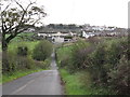
1
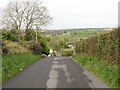
The Back Road descending down to the hamlet of Lissize
Image: © Eric Jones
Taken: 20 Oct 2011
0.11 miles
2
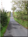
The Back Road climbs over another drumlin
Image: © Eric Jones
Taken: 20 Oct 2011
0.15 miles
3
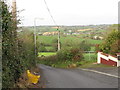
The northern rural fringe of Rathfriland
This view is taken from the Back Road.
Image: © Eric Jones
Taken: 20 Oct 2011
0.19 miles
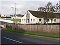
5
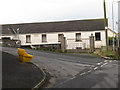
The former Rathfriland National School
This is located at the junction of Back Road and School Road. This building has been converted into a dwelling.
Image: © Eric Jones
Taken: 20 Oct 2011
0.23 miles
6

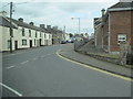
New terraced housing under construction in Newry Street, Rathfriland
Image: © Eric Jones
Taken: 14 Mar 2017
0.24 miles
7
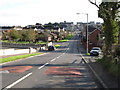
View East along Loughbrickland Road
The road joins with the A25 in the middle ground and climbs on to the summit of the hill under the name Newry Street.
Image: © Eric Jones
Taken: 27 Oct 2011
0.24 miles
8
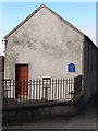
Sunday School house at the Second Presbyterian Church, Rathfriland
The blue plaque commemorates the fact that this building housed the Rathfriland Classical School at the beginning of the twentieth century.
Image: © Eric Jones
Taken: 27 Oct 2011
0.24 miles
9
The Rathfriland Baptist Church, Loughbrickland Road
This building was erected in 1983, some 16 years after the Baptist cause was first established in the town. In May 2006 the church was damaged in an arson attack.
http://www.bbc.co.uk/news/uk-northern-ireland-36329714
Image: © Eric Jones
Taken: 27 Oct 2011
0.24 miles