IMAGES TAKEN NEAR TO
Millfield Manor, NEWRY, BT34 4WA
Introduction
This page details the photographs taken nearby to Millfield Manor, BT34 4WA by members of the Geograph project.
The Geograph project started in 2005 with the aim of publishing, organising and preserving representative images for every square kilometre of Great Britain, Ireland and the Isle of Man.

There are currently over 7.5m images from over14,400 individuals and you can help contribute to the project by visiting https://www.geograph.org.uk
Image Map
Images are licensed for reuse under creativecommons.org/licenses/by-sa/2.0
Notes
- Clicking on the map will re-center to the selected point.
- The higher the marker number, the further away the image location is from the centre of the postcode.
Image Listing (100 Images Found)
Images are licensed for reuse under creativecommons.org/licenses/by-sa/2.0
Image
Details
Distance
1

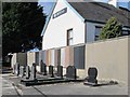
Workshops and dressed stone at Mourne Granite Quarries Ltd, Kilkeel
These buildings are on the west side of Mill Road.
Image: © Eric Jones
Taken: 20 Feb 2011
0.03 miles
2
Gravestones on display at Mourne Granite, Kilkeel
Image: © Eric Jones
Taken: 19 Mar 2011
0.03 miles
3
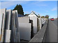
Stocks of dressed and polished Mourne Granite and Italian Marble at Mourne Granite, Kilkeel
Image: © Eric Jones
Taken: 19 Mar 2011
0.03 miles
4

The yard of the Mourne Granite Quarries Ltd, Kilkeel
Granite is cut and polished at this yard to manufacture worktops, building and landscaping stone and monuments. Mourne Granite Quarries occupies land on both sides of the lower section of Mill Road.
Image: © Eric Jones
Taken: 20 Feb 2011
0.03 miles
5
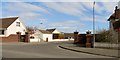
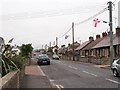
The entrance to the Millvale Estate from Mill Street, Kilkeel
Image: © Eric Jones
Taken: 19 Mar 2011
0.04 miles
8
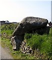
A Neolithic Tomb in the back of Kilkeel's Asda
Not many Asda stores can claim to have a chambered tomb in their back yard. Kilkeel's can.
Image: © Eric Jones
Taken: 19 May 2011
0.08 miles
9
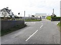
Aughnahoory Road at its junction with Mill Road
Image: © Eric Jones
Taken: 19 Mar 2011
0.09 miles
10
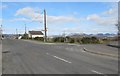
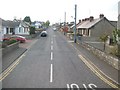
Approaching the junction of Mill Street and Aughnahoory Road
Aughnahoory Road leads out of the town and follows the Kilkeel River northwards towards the Mournes, which can be seen in the background.
Image: © Eric Jones
Taken: 19 Mar 2011
0.09 miles