IMAGES TAKEN NEAR TO
Majors Hill, NEWRY, BT34 4UD
Introduction
This page details the photographs taken nearby to Majors Hill, BT34 4UD by members of the Geograph project.
The Geograph project started in 2005 with the aim of publishing, organising and preserving representative images for every square kilometre of Great Britain, Ireland and the Isle of Man.

There are currently over 7.5m images from over14,400 individuals and you can help contribute to the project by visiting https://www.geograph.org.uk
Image Map
Images are licensed for reuse under creativecommons.org/licenses/by-sa/2.0
Notes
- Clicking on the map will re-center to the selected point.
- The higher the marker number, the further away the image location is from the centre of the postcode.
Image Listing (15 Images Found)
Images are licensed for reuse under creativecommons.org/licenses/by-sa/2.0
Image
Details
Distance
1
A Newry and Mourne District Council Bin Lorry on Majors Hill
This view eastwards was taken from the crossroads.
Image: © Eric Jones
Taken: 16 Mar 2011
0.03 miles
2
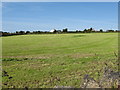
Traditional hay meadow on the corner of Oldtown Road and Majors Hill
Image: © Eric Jones
Taken: 14 Jun 2011
0.04 miles
3
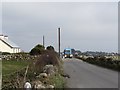
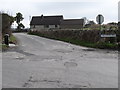
Approaching the cross roads at the upper end of Majors Hill road
At the crossroads Majors Hill becomes Longstone Road. The other two roads are Moneydarragh Road and Oldtown Road.
Image: © Eric Jones
Taken: 14 Jun 2011
0.06 miles
4
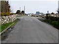
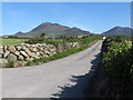
The eastern end of Longstone Road
Longstone Road ends at a crossroads. The continuation eastwards is known as Major's Hill. The two other roads forming the crossroads are, on the left, Oldtown Road and, on the right, Moneydarragh Road.
Image: © Eric Jones
Taken: 16 Mar 2011
0.08 miles
5
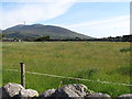
A harvested hay field alongside the Majors Hill road
Image: © Eric Jones
Taken: 14 Jun 2011
0.09 miles
6
Private farm access road off Majors Hill
Image: © Eric Jones
Taken: 14 Jun 2011
0.09 miles
7
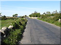
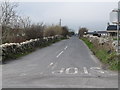
Moneydarragh Road from the crossroads
Moneydarragh Road runs southwards to the coastal village of Annalong.
Image: © Eric Jones
Taken: 16 Mar 2011
0.10 miles
8
Oldtown Road from the crossroads
Oldtown Road links with Head Road which runs parallel with the southern flank of the Mournes.
Image: © Eric Jones
Taken: 16 Mar 2011
0.10 miles
9
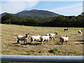
Sheep put in to graze a harvested hay field
Image: © Eric Jones
Taken: 14 Jun 2011
0.14 miles
10
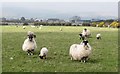
Blackface Mourne Sheep in a field alongside Oldtown Road
Houses on Oldtown Road and Oldtown Lane can be seen in the background. In summer the sheep are grazed on the uplands.
http://www.bbc.co.uk/programmes/p00c7rc2
Image: © Eric Jones
Taken: 16 Mar 2011
0.18 miles